Menu
DestinationsLocationsBlogMapAbout
mountain · da lat

Langbiang Mountain

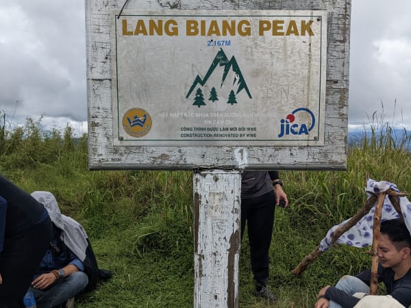
Langbiang is a mountain range north of Đà Lạt topped by Núi Bà, its highest peak at 2,167 metres - most visitors instead reach the easier, jeep-accessible Đồi Ra-đa (Radar Hill) viewpoint, while the true summit is a genuine trek through Bidoup-Núi Bà National Park, home to the K'Ho ethnic minority and their legend of the star-crossed lovers K'Lang and H'Biang.

Highest Peak near Đà LạtTrekkingSunrise ViewsK'Ho Culture
Get Directions
Best Time to Visit
Nov - Mar is the dry season and the most reliable window - cooler, drier trails, and the local mai anh đào (wild Himalayan cherry) blossoms bloom during this stretch. Feb - Mar specifically tends to offer the most ideal trekking temperatures (around 18-22°C, sunny, little rain). Apr - Oct is the rainy season - trails get genuinely muddy, slippery, and buggy (mosquitoes and leeches), and is best avoided for the Núi Bà trek specifically. Start early morning if cloud-hunting at the summit is a priority
Entry Fee
Around 50,000 VND/adult, 25,000 VND/child for park entry; jeep to Đồi Ra-đa (Radar Hill), shared vehicle round trip, runs roughly 100,000-150,000 VND/person depending on timing - prices and exact policies shift periodically, so confirm current rates locally
Opening Hours
5:30 AM - 5:00 PM
Address
Lạc Dương, Lâm Đồng
Crowds
Đồi Ra-đa is popular with tour groups and jeep visitors and can feel crowded, especially around the viewpoint areas; the Núi Bà trekking route sees far fewer people
Difficulty
Đồi Ra-đa is easy, suitable for most visitors. The Núi Bà trekking route is easy to moderate for most of its length, but the final stretch to the peak is steep and can be slippery, especially after rain, requiring some hands-on scrambling and proper hiking footwear
Safety
Wear a hat and stay hydrated on the trek; snakes are occasionally present (mostly harmless); keep belongings secure; the ranger station logs hikers' names for safety tracking on the Núi Bà route; many find the descent harder on the knees than the climb up
Accessibility
Entrance fee applies (confirm current pricing locally). An official paved path serves Đồi Ra-đa, with jeep/shuttle service available for those who don't want to walk. Access to Núi Bà's true summit can be more restricted or seasonally limited - confirm current status before planning a trip specifically around reaching it, since Đồi Ra-đa may be the only realistic option at certain times
Seasonal
March is often cited as ideal: cool, dry, minimal insects, lush greenery. Avoid rainy periods, when the Núi Bà trekking trail in particular becomes muddy and slippery

What Makes Langbiang Mountain Special

Langbiang is a small mountain range just north of Đà Lạt, within Bidoup-Núi Bà National Park, one of Vietnam's four key biodiversity centres. Its highest point, Núi Bà, reaches 2,167 metres, alongside the lower Núi Ông and Đồi Ra-đa (Radar Hill). Most visitors, though, don't actually reach Núi Bà's true summit - the far more common experience is Đồi Ra-đa, an easier, jeep-accessible viewpoint with cafes, flower gardens, a telescope area, and horse riding, offering sweeping views over Đà Lạt, the pine forests, and Đan Kia - Suối Vàng lake in the distance. Reaching Núi Bà's actual peak instead means a genuine trek through primary montane forest via a Bidoup-Núi Bà National Park ranger checkpoint, where hikers heading for the true summit need to register - a different, more demanding experience from the Radar Hill visit that most tour itineraries include. It's also worth setting expectations honestly: the true summit itself is little more than a small dirt clearing with a summit marker sign - the panoramic view over Đà Lạt is the entire reward, with no services, shade, or shelter up there, so it rewards the journey more than the destination itself. The name Langbiang comes from K'Ho legend: K'Lang and H'Biang were young lovers from feuding tribes whose deaths, according to the story, led their families to make peace - the mountain is named for them, and the legend remains central to the cultural identity of the K'Ho people who have lived on the Đà Lạt plateau for centuries.

Getting There

Langbiang is about 12km north of Đà Lạt city centre in Lạc Dương District. By motorbike, the base station is approximately 25 minutes from central Đà Lạt on Highway 723 - just follow Google Maps. A local bus also runs to Langbiang, departing from around 48 Lạc Dương street in Đà Lạt roughly every 15-30 minutes between 5:30 AM and 7 PM, a workable budget option if you'd rather not ride yourself. Grab rides are available but return trips can be difficult to book from the remote base - motorbike or the bus are the more practical options. From the base, most visitors take a shared jeep up to Đồi Ra-đa (round trip, shared vehicle, around 120,000 VND/person) or walk the easier route on foot. Trekking to Núi Bà's true summit instead starts from the same general area but follows a separate, longer trail through a Bidoup-Núi Bà National Park checkpoint - ask locally about current access and conditions for this route specifically, since it's a genuinely different undertaking from the Radar Hill visit.

On the Ground

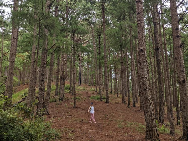
The base area has a K'Ho cultural village with traditional longhouses, a small museum, and craft and food stalls, plus horses available for photos or a short ride. Most visitors head up to Đồi Ra-đa, where cafes, flower gardens, a telescope viewing area, and clear views (on good days) over Đà Lạt and the surrounding pine forest await, reached easily by jeep or on foot. The separate trek toward Núi Bà's true summit climbs through pine forest, with noticeable changes in vegetation as you gain elevation, before transitioning to old-growth montane forest on the upper slopes - the final half of the climb gets genuinely steep (roughly 45 degrees in places) on a dirt trail that turns very slippery when wet, so this route is best avoided in rainy conditions. Camping at the summit itself isn't a good idea despite the temptation - it's cold, exposed to strong wind with no tree cover, and the clearing is small. Some hikers continue on from Núi Bà to Núi Ông (the 'male' peak), but there's no marked trail for that extension and it genuinely requires an experienced local guide - and there isn't much to see there beyond dense old-growth forest, so most visitors get the full experience from Radar Hill and the Núi Bà summit alone. Cloud inversions in the valleys below are common in the early morning, particularly in the dry season, and this is regarded as one of the better cloud-hunting spots near Đà Lạt.

Tips

Langbiang works for very different kinds of visitors depending on which experience you're after: Đồi Ra-đa is a relaxed, easy outing suitable for most fitness levels and travel styles, while the trek to Núi Bà's actual summit is a genuinely demanding full-day hike best suited to fit, well-prepared hikers. Decide which one you actually want before you go, since they're not the same trip. If sunrise and cloud-hunting are the goal, an early departure from Đà Lạt (around 4:30-5:00 AM) gets you there before the crowds and gives the best chance of catching the cloud inversion in the valleys below. Whichever route you take, this is one of the more rewarding outdoor half-days or full days available from Đà Lạt.

Based on real traveler experiences and commonly mentioned advice from multiple visitors.

If trekking to Núi Bà, start right at the trailhead near the ticket gate and get a proper map if possible - signage can be poor and there are unmarked side paths
Bring more water than you think you need for the trek; only the ranger station partway up sells supplies, and there's nothing at the summit itself
Stick to the official route on the way down rather than any unofficial shortcuts, which can be dangerous when wet. Budget around 5 hours round trip for the full Núi Bà trek, including roughly an hour for the final ascent
Search 'Khu du lịch Langbiang' on maps rather than just 'đỉnh Langbiang' (Langbiang peak) - the latter can point you toward the trekking trailhead or a different spot on the range rather than the main entrance
Most visitors go to Đồi Ra-đa (Radar Hill) rather than the true summit - it's an easier, jeep-accessible viewpoint with cafes, flower gardens, telescopes, and horse riding, and is what most people mean when they say they've 'visited Langbiang.' A lot of people mistake Radar Hill for the actual peak, but it isn't - vehicles can't reach the true summit at all, and getting there requires trekking on foot
The main trail up to Núi Bà's true summit is manageable solo for confident, experienced hikers (allow roughly 5 hours round trip if you don't linger), though a companion is still worth having given how quickly Đà Lạt's weather can turn, especially in the wetter months. Getting mildly lost happens fairly often here but usually isn't dangerous, since the mountain is bordered by villages and farmland - if you lose the trail, stay calm and follow any gently sloping path downhill; if you're inexperienced, it's often safer to just stay put and wait rather than wander further
Register at the ranger station at the base if you're heading for the true summit (Núi Ông/Bà) - this is required, not optional
Start the trek or jeep ride before 6 AM if sunrise and cloud-hunting are the priority - the light on the surrounding peaks and cloud inversions in the valleys below are best early, before crowds arrive
If trekking the full Núi Bà route, wear proper shoes - the trail is steep in its final stretch and genuinely slippery after rain, with some sections requiring hands-on scrambling
The K'Ho cultural village at the base has traditional longhouses, craft demonstrations, and sometimes gong (cồng chiêng) performances - worth 30 minutes before or after your visit
Bring a warm layer and a thin rain jacket - mountain weather here changes quickly, and the upper slopes are consistently cooler and windier than Đà Lạt town. Good hiking shoes with real grip, a 20-30L daypack, a sun hat, insect repellent, a flashlight, and a power bank round out a sensible packing list
Only the ranger station partway up sells water and snacks, and there are no facilities at the true summit - carry enough water (2-3 litres per person) and energy snacks for the full round trip if trekking

Common questions from travelers who've visited this place.

Is visiting Langbiang free?
No - a park entrance fee applies (commonly cited around 50,000 VND/adult, though this can vary and is worth confirming locally), and the jeep to Đồi Ra-đa is a separate cost (around 120,000 VND/person round trip, shared vehicle).
Can I drive to the summit?
Private vehicles aren't taken all the way up. A shared jeep/shuttle service runs to Đồi Ra-đa, the popular viewpoint most visitors reach; getting to Núi Bà's actual highest peak instead requires trekking on foot via a separate route.
What should I bring for the hike?
Proper hiking shoes with good grip, a hat, sunscreen, and your own water and snacks - only the ranger station partway up the Núi Bà route sells supplies, and there's no shade or facilities at the summit itself.
Explore more
da lat - Full Guide
View destination guide →