78 places
Trekking in Vietnam
Multi-day trails through Vietnam's wildest terrain
78 locations for trekking

📍 Landmark
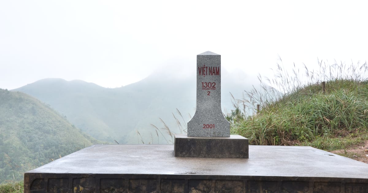
A Pa Chai (Vietnam's Westernmost Point)
📍 dien bien
A Pa Chai is Vietnam's westernmost point - a remote peak in Điện Biên province where the borders of Vietnam, Laos, and China meet at a tri-border marker, reached via Đồn Biên Phòng 317 in Mường Nhé district's Sín Thầu commune.

🪨 Cave
Am Tiên Cave
📍 ninh binh
Am Tiên Cave - nicknamed 'Tuyệt Tình Cốc' after its wuxia-film-like scenery - is a dragon-mouth-shaped grotto above a jade-green lake in the Hoa Lư valley, reached by around 200-250 stone steps, with a dark history as an execution ground under Đinh Tiên Hoàng and a later connection to Queen Dương Vân Nga's Buddhist retreat.
🏔️ Mountain
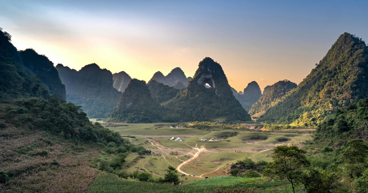
Angel Eye Mountain (God Eye Mountain)
📍 cao bang
Angel Eye Mountain - also known as God Eye Mountain or Núi Thủng - is a limestone karst peak in Cao Bằng with a perfectly circular 50m hole piercing through its summit, set in the Thang Hen valley where the surrounding flatland floods into a 15-hectare lake each rainy season.

📍 Lake
Ba Be Lake
📍 bac kan
Ba Be Lake is Vietnam's largest natural freshwater lake - three connected bodies of water (Pé Lèng, Pé Lù, Pé Lầm) stretching 8km through karst mountains in Bắc Kạn. Ramsar Wetland site, Tày homestays, boat through Puong Cave, and some of the most intact lowland forest in the northern highlands.
🏔️ Mountain
Ba Den Mountain
📍 tay ninh
Ba Den Mountain is the highest peak in southern Vietnam at 986 metres, rising sharply from the flat Tay Ninh plain and visible for 50km in every direction. A major Buddhist and Cao Dai pilgrimage site with three cable car lines, a 72-metre bronze Lady Buddha statue, and trekking trails through forest to the top.
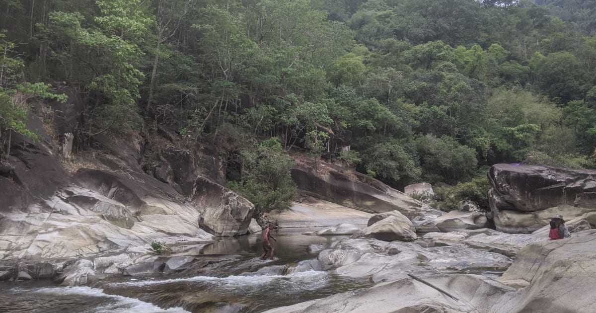
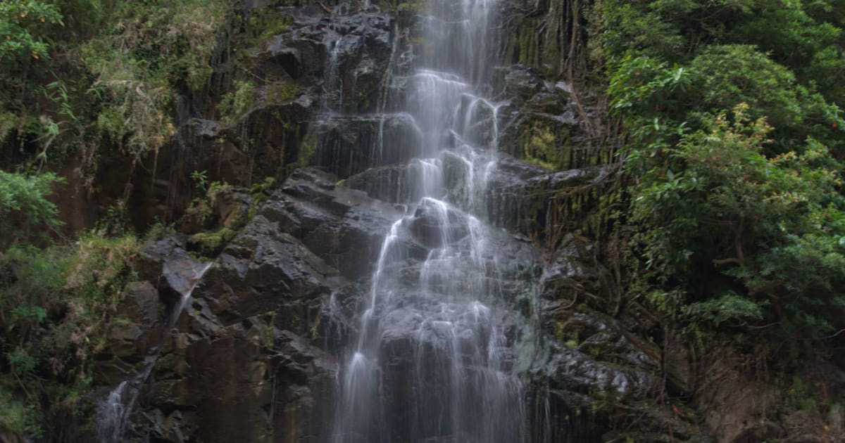
💧 Waterfall
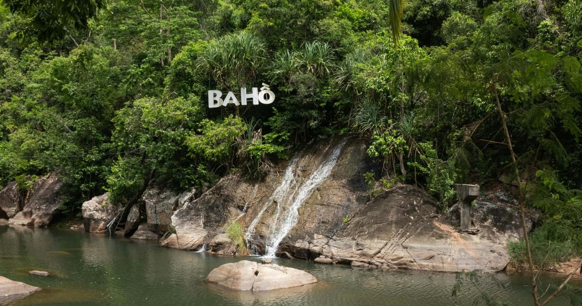
Ba Hồ Waterfall
📍 khanh hoa
Ba Hồ Waterfall is Nha Trang's best jungle adventure - three tiered pools fed by a 10km stream running off 660m Hòn Sơn peak, 25km north of the city. The trail between pools stays genuinely rugged and undeveloped even though basic facilities exist near the entrance, so this rewards visitors prepared for real rock scrambling rather than a casual walk.

🌿 Nature
Bắc Sơn Valley
📍 lang son
Bắc Sơn Valley in Lạng Sơn is a wide basin of patchwork rice paddies ringed by dramatic limestone karst peaks - 80km from Lạng Sơn city, home to Tày, Nùng, and Dao communities in traditional stilt houses. One of northern Vietnam's most photogenic and least-visited valley landscapes.
🏖️ Beach
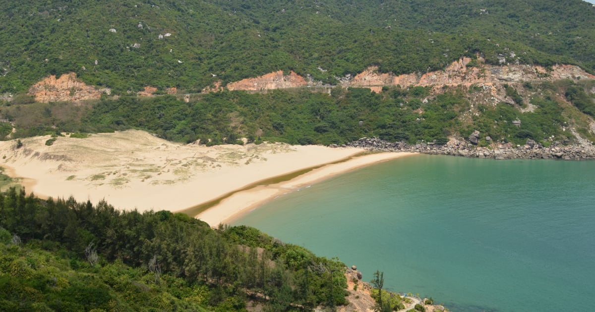
Bãi Môn Beach
📍 phu yen
Bãi Môn is a pristine 400m crescent beach at the foot of Mũi Điện in Phú Yên - sheltered between two headlands, with a freshwater stream running to the sea, and one of the first places on mainland Vietnam to receive the sunrise each morning.

🏝️ Island
Bai Tu Long Bay
📍 quang ninh
Bái Tử Long Bay - Ha Long's quieter neighbour to the northeast - shares the same UNESCO karst landscape with 600+ islands but far fewer cruise boats. Named for the legend of dragon children landing to protect Vietnam. Ha Long Bay the way it was before mass tourism.

🌿 Nature
Ban Gioc Waterfall
📍 cao bang
Bản Giốc is the largest waterfall on any national border in Southeast Asia - a 300-metre-wide curtain of water crashing across three tiers on the Vietnam-China border in Cao Bằng, surrounded by karst mountains and emerald pools.

📍 Lake
Bàu Sấu (Crocodile Lake)
📍 dong nai
Bàu Sấu is a remote oxbow lake deep inside Cát Tiên National Park - a 3-hour jungle trek from the park headquarters leads to one of southern Vietnam's last viable crocodile habitats and a prime birdwatching site.

🌿 Forest
Bidoup Núi Bà National Park
📍 lam dong
Bidoup Núi Bà National Park protects one of the largest remaining tracts of highland cloud forest in southern Vietnam - a roughly 64,800-hectare wilderness of montane jungle, endemic birds, and multi-day trekking routes 50km north of Đà Lạt, centred on Bidoup Peak, the highest point of the Đà Lạt Plateau.
🏔️ Mountain
Bình Liêu Border Mountains
📍 quang ninh
Bình Liêu in Quảng Ninh is often called a 'mini Sa Pa' - a highland border district with year-round mild climate, ethnic minority villages, and nearly 50km of frontier with China. The border ridge trek to Cột Mốc 1305 crosses the famous dinosaur spine ridge above a sea of reed flowers in October and November.

🌿 Forest
Bù Gia Mập National Park
📍 binh phuoc
Bù Gia Mập National Park is one of the last intact lowland rainforest blocks in southeastern Vietnam - 26,000 hectares on the Cambodian border, 200km from Saigon. Difficulty 2/10, suitable for beginners. Famous for leeches, gibbon calls at dawn, and camping by Đắk Manh stream.

🏔️ Mountain
Bùi Hui Grassland
📍 quang ngai
Bùi Hui Grassland is a highland meadow at 700m elevation in Ba Tơ district, Quảng Ngãi - a wide-open landscape of rolling hills, sim berry shrubs, and cool mountain air, home to the H're ethnic minority and one of Quảng Ngãi's most scenic camping destinations.

📍 History
Cát Bà Cannon Fort
📍 hai phong
Cát Bà Cannon Fort is a French and Japanese military installation from the 1940s on the hilltop above Cát Bà town - currently closed long-term to visitors. The nearby Radio Tower viewpoint offers comparable panoramic views over Lan Hà Bay and Cát Bà town as an alternative.
🌿 Forest
Cát Bà National Park
📍 hai phong
Cát Bà National Park covers 17,363 hectares of the island's rugged interior - the last habitat of the critically endangered golden-headed langur, with jungle trails to a summit viewpoint over Ha Long Bay and Lan Hà Bay simultaneously, a 12km trek through primary forest to Việt Hải village, and butterfly swarms along the trails in April and May.
🌿 Forest
Cát Tiên National Park
📍 dong nai
Cát Tiên National Park - established 1992, 71,920 hectares (larger than Singapore), UNESCO Biosphere Reserve. Over 1,610 plant species, 1,568 animal species, 300+ bird species (nearly 50% of Vietnam's total). Once the last mainland Asian refuge of the Javan rhinoceros, declared extinct here in 2010. Winner of 4 awards at the 2025 AEN International Ecotourism Awards including top prize for Biodiversity Conservation.

🏔️ Mountain
Núi Chứa Chan (Chứa Chan Mountain)
📍 dong nai
Núi Chứa Chan (also known as Gia Ray or Gia Lào) is the second-highest peak in southern Vietnam after Núi Bà Đen, about 100-110km from Ho Chi Minh City. A cable car reaches the cave pagoda partway up, while a numbered power-pole trail leads hikers on to the summit through forest, past old French colonial and wartime relics, to camping spots with sweeping views over the Đồng Nai plains.
🌿 Nature
Con Dao National Park
📍 vung tau
Con Dao National Park - Vietnam's premier wildlife and marine conservation area. 19,883 hectares, Ramsar Wetland since 2013. Vietnam's most important sea turtle site: 400+ turtles nest annually. Three endemic species found nowhere else on earth. Rainforest trekking, coral reefs, dugong, and sea turtles in one protected area.
💧 Waterfall
Cửa Tử Stream
📍 thai nguyen
Suối Cửa Tử in Thái Nguyên province is a 9-gate stream trek through primary forest in Đại Từ district, approximately 2 hours from Hanoi - with natural swimming pools, waterfall jumps, and camping options that make it one of the most accessible wilderness day trips from the capital.
💧 Waterfall
Đa Ploa Stream
📍 lam dong
Đa Ploa Stream in Đạ Huoai district of Lâm Đồng is a remote multi-tier Stream in the transitional forest zone between the southern highlands and the lowlands - visited almost exclusively by Vietnamese travelers and largely absent from foreign-language travel content.
🌿 Nature
Dark Cave
📍 quang binh
Dark Cave is Phong Nha's most adventurous experience - a zip line over the Son River, kayaking into a pitch-black cave, swimming through underground passages, and a mineral mud bath inside the cave chamber, all packaged into one of Vietnam's best adventure activities.

💧 Waterfall
Datanla Waterfall
📍 lam dong
Datanla Waterfall is Đà Lạt's most accessible cascade - a 20m multi-tier waterfall 5km from the city centre on Prenn Pass, reached by an alpine coaster (one track is among Southeast Asia's longest at 2,400m), ziplining, canyon swinging, or a gentle forest walk. Named from K'ho language for 'water under the leaves'.
🏔️ Mountain
Núi Dinh (Dinh Mountain)
📍 ba ria vung tau
Núi Dinh is a 504m coastal peak in Bà Rịa–Vũng Tàu province - the highest point in the region, with forested trails, a summit pagoda, and panoramic views over the Vũng Tàu peninsula and the South China Sea.

🏖️ Beach
Đồi Nhái Beach
📍 ba ria vung tau
Đồi Nhái Beach is a 3.8km undeveloped stretch of coastline near Phước Tỉnh in Bà Rịa-Vũng Tàu - no facilities, no crowds, and one of the better sunrise spots on the southern coast within 100km of Ho Chi Minh City.

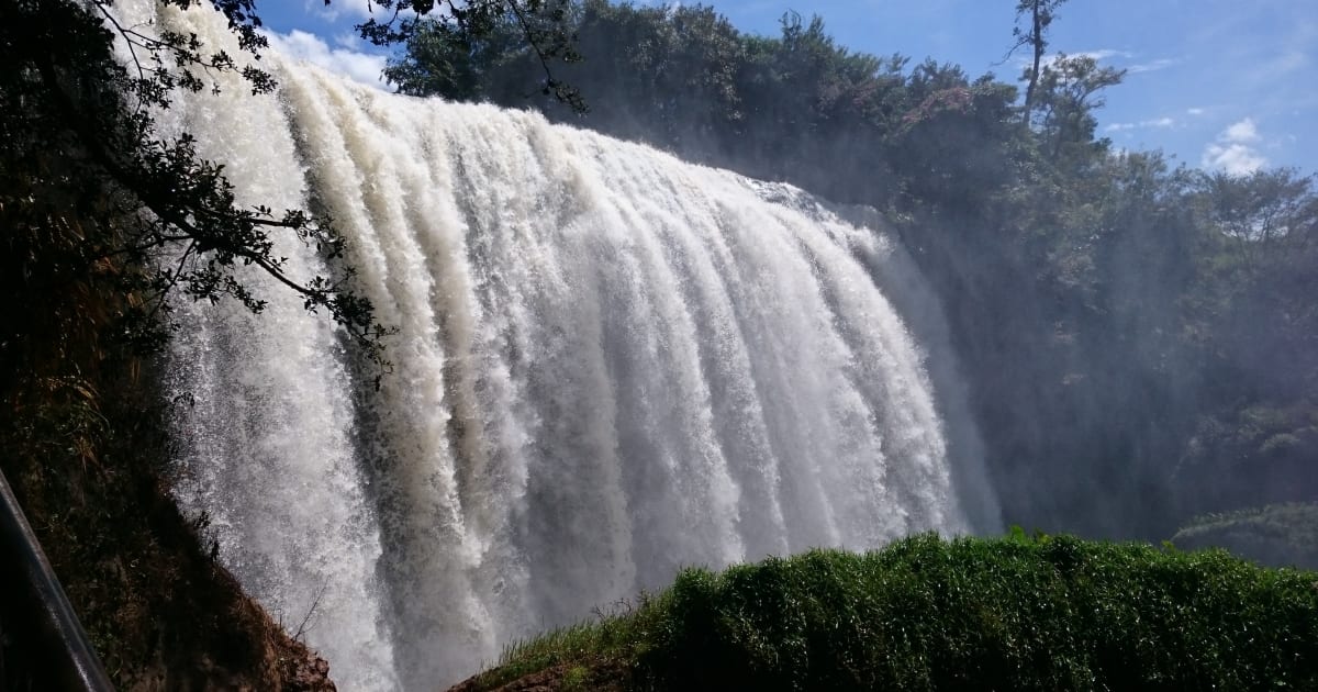
💧 Waterfall
Do Quyen Waterfall (Rhododendron Waterfall)
📍 hue
Thác Đỗ Quyên (Rhododendron Waterfall) in Bạch Mã National Park drops nearly 400 metres through primary mountain forest - reached by 689 stone steps or via an adventure package with via ferrata, zipline, and suspension bridge. One of the tallest waterfalls in central Vietnam.
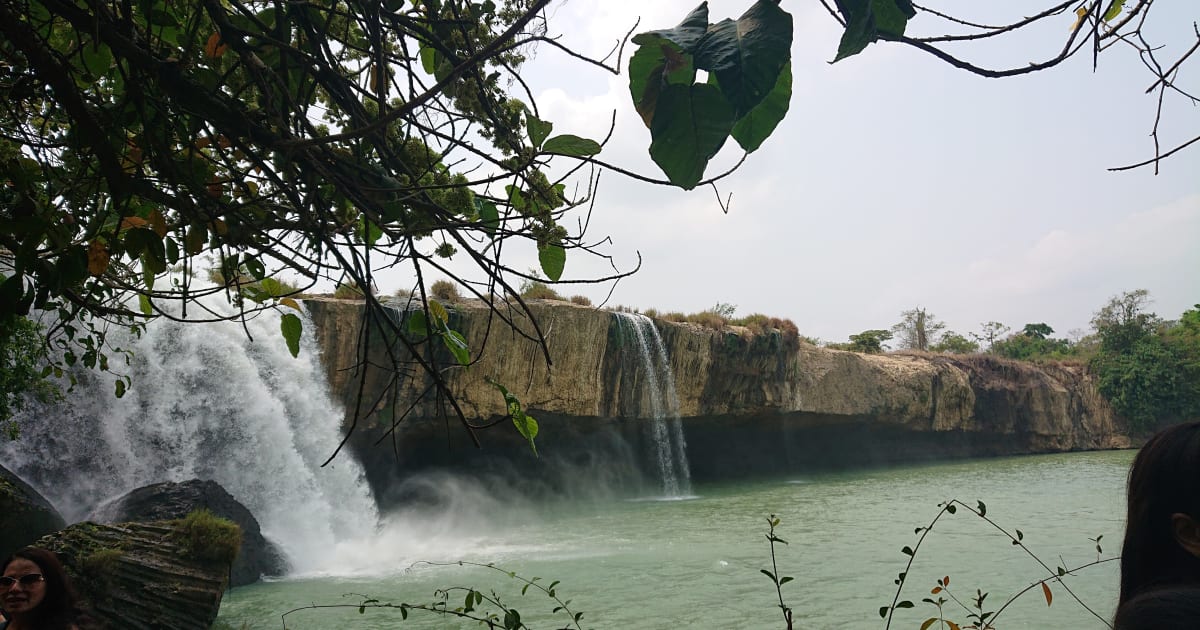
💧 Waterfall
Dray Nur & Dray Sap Waterfalls
📍 dak lak, dak nong
Dray Nur and Dray Sap are twin waterfalls on the Krông Ana river straddling the Đắk Lắk and Đắk Nông border - two of the widest waterfalls in the Central Highlands, known locally as the Husband and Wife Falls.
🎎 Cultural
Du Già Village
📍 ha giang
Du Già is a Tày and H'mông village 70km from Hà Giang city on the eastern Ha Giang Loop - quieter and harder to reach than the main loop, with rice terraces, red silk-cotton trees lining the road, and homestays that attract travellers who want the experience over the Instagram shot.
💧 Waterfall
Du Già Waterfall
📍 ha giang
Du Già Waterfall (Thác Ba Tiên) is a tiered cascade in Yên Minh district on the eastern Ha Giang Loop - known locally as the Three Fairies Waterfall, with two cliff jumping levels at 3.5m and 6m and cold clear water that makes it the best place to refresh after a dusty day on the loop.
🪨 Cave
Eight Ladies Cave
📍 quang binh
Eight Ladies Cave is one of Vietnam's most sacred war memorials - a limestone cave in Phong Nha-Kẻ Bàng where eight young female volunteers were killed by American bombing in 1972 while sheltering inside, reached by a jungle trek and visited as a place of pilgrimage by Vietnamese travellers.

🏔️ Mountain
Elephant Mountain
📍 dak lak
Elephant Mountain near Buôn Ma Thuột rises above the Central Highlands coffee belt and takes its name from the wild elephant herds that have roamed its forested slopes for centuries - still one of the few places in Vietnam where elephants exist in semi-wild conditions.
💧 Waterfall
Elephant Waterfall
📍 lam dong
Elephant Waterfall is the most dramatic waterfall near Đà Lạt - a powerful 30-metre cascade surrounded by volcanic rock formations resembling an elephant, with a narrow path that leads behind the falling water through a cave at the base.

🌿 Nature
Fansipan
📍 lao cai
Fansipan - the Roof of Indochina at 3,143m - is Vietnam's highest peak. Two ways to the summit: cable car (15 min, world's longest 3-rope gondola at 6,292m) or 2-3 day trek through ancient cloud forest. Buy tickets on Klook to skip the queue.
🏔️ Mountain
Núi Giếng Tiền
📍 quang ngai
Núi Giếng Tiền is one of Lý Sơn's extinct volcanic craters on the island's southern side, visible from Cổng Tò Vò and home to Chùa Đục on its lower slopes. Less visited than Núi Thới Lới, it offers a quieter perspective over the island's eastern coast and garlic fields.
🌿 Nature
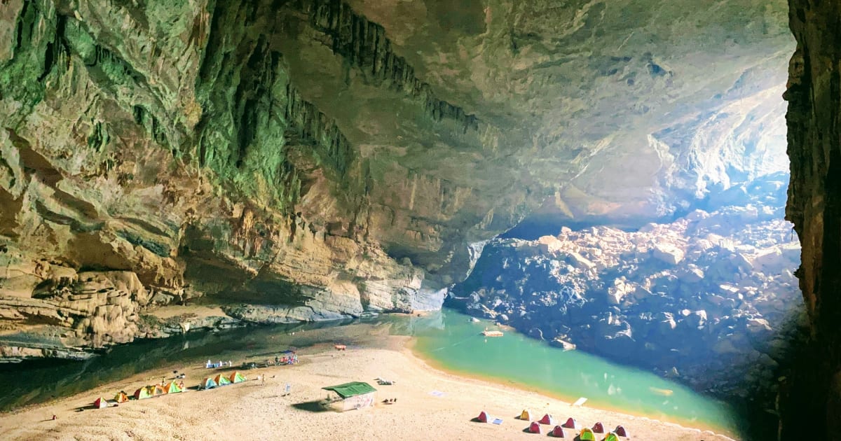
Hang En Cave
📍 quang binh
Hang En is the third largest natural cave in the world - 3km from Sơn Đoòng, accessible by 2-day 1-night trek through jungle and Bru-Vân Kiều village, with a night camping on a white sandbar inside the cave under a 145m ceiling. The accessible alternative to Sơn Đoòng.
🌿 Nature
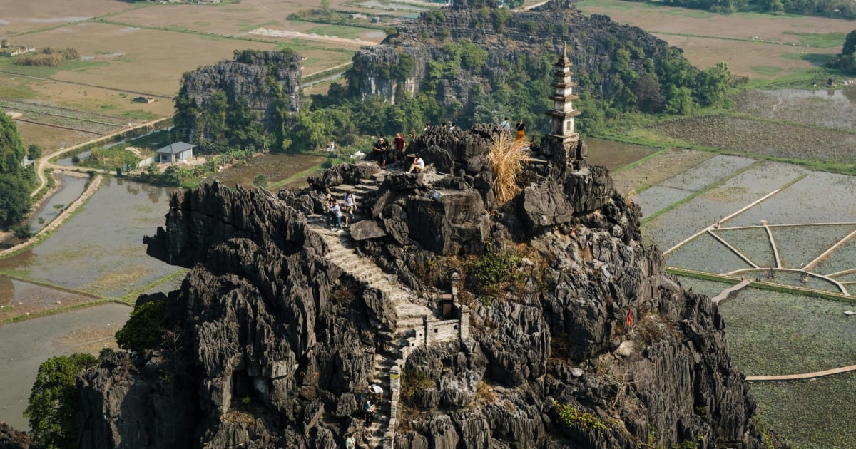
Hang Mua
📍 ninh binh
Hang Mua is Ninh Bình's best viewpoint - 486 stone steps up Ngọa Long peak (200m) for a panoramic view over Tam Cốc valley, the Ngô Đồng River, and karst fields. Best May-June for golden rice. Search 'Mua Cave' on Google Maps - the Vietnamese name pins the wrong location.

🏖️ Beach
Hang Rai
📍 ninh thuan
Hang Rai is a wild stretch of Ninh Thuận coastline inside Núi Chúa National Park - ancient coral rock formations shaped by centuries of waves, best at sunrise or late afternoon when the light turns the jagged stone red and gold. Part of the Vĩnh Hy - Hang Rai - Vườn Nho coastal route.

💧 Waterfall
K50 Waterfall
📍 gia lai
K50 Waterfall (Thác Hang Én) is a 54-metre cascade inside Kon Chu Rang Nature Reserve on the Gia Lai–Bình Định border - accessible only by multi-day trek with permits, with a swallow cave behind the falls, a King Kong-shaped boulder in the pool, and leeches regardless of season.
🌿 Nature
Khau Cóc Chà Pass
📍 cao bang
Khau Cóc Chà Pass is one of the most dramatic mountain roads in Cao Bằng - a high-altitude route through cloud forest connecting Nguyên Bình to the Phia Oắc massif, with sweeping views over the southern Cao Bằng plateau and valley systems that rival anything on the Ha Giang Loop.

🏔️ Mountain
Khau Phạ Pass
📍 yen bai
Khau Phạ Pass is one of Vietnam's four great mountain passes - a 30km road through the clouds between Tú Lệ and Mù Cang Chải, with the most dramatic views of rice terraces in the country cascading down both sides of the valley below.

🌿 Nature
Khe Van Waterfall
📍 quang ninh
Khe Van Waterfall in Binh Lieu, Quang Ninh is the largest waterfall in the province - a wild three-tier cascade dropping through dense forest in San Chi ethnic minority territory, 100km northeast of Ha Long and almost entirely off the foreign tourist trail.

📍 River
La Ngâu Stream
📍 binh thuan
La Ngâu Stream in Tánh Linh, Bình Thuận is a rocky jungle stream with natural pools and multiple campsites - one of the top weekend camping destinations from Ho Chi Minh City (4-5 hours). No electricity, weak signal, cold water, and a dam that releases without warning. Far enough from Saigon to feel genuinely removed. Close enough for a 2-day trip.

🏔️ Mountain
Langbiang Mountain
📍 lam dong
Langbiang Mountain is the highest peak in the Đà Lạt plateau at 2,167 metres - a twin-peaked massif rising above pine forest north of the city, home to the K'Ho ethnic minority, with a summit trek rewarded by panoramic views over the entire Central Highlands.
✨ Attraction
Lũng Cú Flag Tower
📍 ha giang
Lũng Cú Flag Tower stands on Dragon Mountain at Vietnam's symbolic northernmost point - a 33.15m octagonal tower (rebuilt 2010) flying a 54 sq metre flag for Vietnam's 54 ethnic groups, with history tracing back to Lý Thường Kiệt's first border flag. 839 steps to the summit, with China visible across the valley.
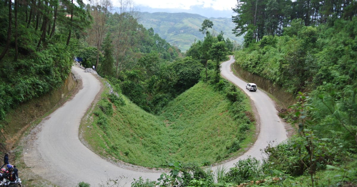
🏔️ Mountain
Mã Pí Lèng Pass
📍 ha giang
Mã Pí Lèng Pass - Vietnam's most dramatic mountain road, a 20km switchback carved into sheer limestone cliffs above the turquoise Nho Quế River canyon. Built 1959-1965 by over 2,000 workers from 16 ethnic groups who hung from ropes on the cliff faces for nearly a year.

🏔️ Mountain
Masara Hill
📍 lam dong
Masara Hill in Đức Trọng district, Lâm Đồng is a 30-hectare expanse of open grassland that turns pink from mid-November to mid-December - one of the few places in Vietnam where this seasonal transformation happens at scale, and largely unknown to foreign visitors.

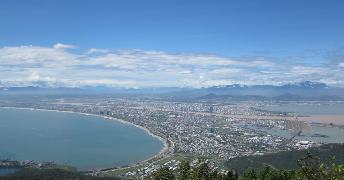
🏯 Heritage
Marble Mountains (Ngũ Hành Sơn)
📍 da nang
Ngũ Hành Sơn (Marble Mountains) in Đà Nẵng is a cluster of five marble and limestone peaks with caves, Buddhist shrines, ancient Cham sanctuaries, and sweeping sea views - most famously the Huyền Không Cave where sunlight shafts through a collapsed ceiling onto Buddhist altars below.
🏔️ Mountain
Mẫu Sơn Mountain
📍 lang son
Mẫu Sơn is one of the few places in Vietnam where snow falls - a 1,541m massif in Lạng Sơn province near the Chinese border that experiences genuine subalpine conditions in winter, with frost, occasional snowfall, and a sea of clouds that makes it one of the most dramatic landscapes in the northeast.

🏔️ Mountain
Minh Đạm Mountain
📍 vung tau
Minh Đạm Mountain is a forested coastal peak in Bà Rịa-Vũng Tàu that served as a Viet Cong resistance base during both the French and American wars - a historically significant trekking site with cave systems, war remnants, and views over the southeastern coast.
🌿 Nature
Mooc Spring
📍 quang binh
Mooc Spring is Phong Nha's most beautiful swimming spot - a natural spring emerging from the karst limestone in a jungle clearing, forming a series of turquoise pools and a gentle waterfall, 7km from Sơn Trạch and one of the most scenic outdoor pools in central Vietnam.
🌿 Nature
Mũi Điện (Cape Varella)
📍 phu yen
Mũi Điện (Cape Varella) in Phú Yên is a dramatic 110-metre headland crowned by a working lighthouse - traditionally regarded as the easternmost accessible point of mainland Vietnam, and one of the first places on the country's coastline to receive sunrise.
🌿 Nature
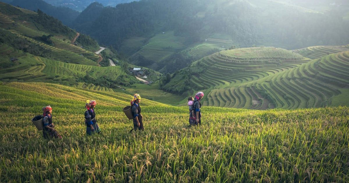
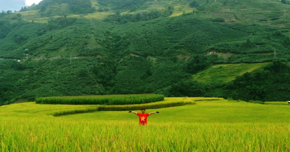
Muong Hoa Valley
📍 lao cai
Muong Hoa Valley - Sa Pa's most iconic trekking corridor - stretches 15km through Vietnam's largest rice terrace system (2,200+ hectares), H'Mông and Giáy villages, and the 3,000-year-old Ancient Rock Field. 8-10km from Sa Pa town, changes colour with every season.

🏔️ Mountain
O Quy Ho Pass
📍 lao cai, lai chau
Ô Quy Hồ Pass is one of Vietnam's 'tứ đại đỉnh đèo' (four great passes) - the longest mountain pass in the northwest at 50km, crossing the Hoàng Liên Sơn range at 2,035m between Sapa and Lai Châu. Named after the mournful cry of a bird in a tragic love legend.

💧 Waterfall
Pa Sy Waterfall
📍 kon tum
Pa Sy Waterfall is a remote multi-tier cascade deep in the primary forest of Đắk Glei district, Kon Tum - one of the least-visited waterfalls in the Central Highlands, reached by a trail through jungle inhabited by local Jẻ-Triêng minority communities.
📍 History
Pác Bó Historic Site
📍 cao bang
Pác Bó is where Hồ Chí Minh secretly returned to Vietnam on January 28, 1941, after 30 years in exile - establishing his jungle base in a limestone cave beside the Lenin Stream, 50km north of Cao Bằng city near the Chinese border.
🌿 Nature
Paradise Cave
📍 quang binh
Paradise Cave (Động Thiên Đường) is one of Asia's longest dry caves at 31.4km - the 'underground palace' discovered in 2005 by a local man following cool air from a rock crevice, opened to visitors in 2010. A 1km wooden boardwalk leads through chambers up to 100m high, with stalactite formations resembling Buddhist figures and Champa towers.

💧 Waterfall
Phi Liêng Waterfall
📍 lam dong
Phi Liêng is a 7-tier, 70m waterfall deep in the forest of Đam Rông district, Lâm Đồng - nicknamed 'Tây Nguyên Đệ Nhất Thác' (the greatest waterfall of the Central Highlands). 80km from Đà Lạt, no phone signal inside, a 40-45 degree descent with ropes - genuinely remote and genuinely rewarding.
🌿 Nature
Phong Nha Botanic Garden
📍 quang binh
Phong Nha Botanic Garden is a 2,000-hectare protected forest reserve on the edge of Phong Nha-Kẻ Bàng National Park - a network of jungle trails, a canopy walkway, and some of the most accessible wildlife habitat in central Vietnam, 7km from Sơn Trạch village.

🌿 Nature
Quản Bạ Heaven Gate
📍 ha giang
Quản Bạ Heaven Gate is the first dramatic viewpoint on the Ha Giang Loop - a mountain pass at 1,500 metres where the road crests and the entire Quản Bạ Valley opens below, with the Twin Mountains rising from the valley floor and, in the right season, a sea of clouds filling the basin at dawn.

🏔️ Mountain
Quản Bạ Twin Mountains
📍 ha giang
The Quản Bạ Twin Mountains - Núi Đôi, 'Double Mountains' - are two symmetrical limestone peaks rising from the Quản Bạ Valley floor, an icon of the Ha Giang Loop and the subject of a Tày legend about a fairy who left her twin children behind when she was called back to heaven.
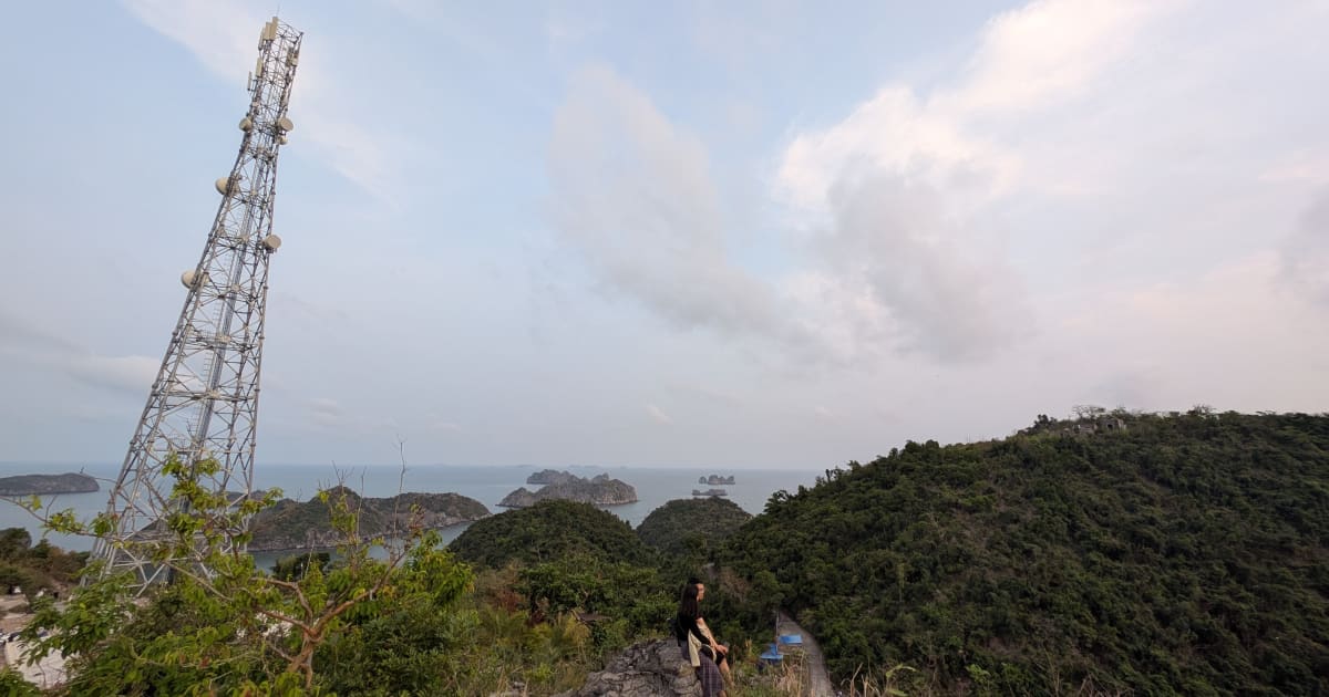
📍 Landmark
Radio Tower Viewpoint
📍 hai phong
The Radio Tower viewpoint on Cat Ba Island is the best accessible sunset spot since Cannon Fort closed in late 2025 - a Viettel telecom tower near the summit of Nui Ngoc offering panoramic views over Lan Hạ Bay, Ben Beo harbour, and Cat Ba town from nearly 100 metres above sea level.

🌿 Nature
Son Doong Cave
📍 quang binh
Son Doong is the largest cave in the world - big enough to contain a 40-story skyscraper, with its own weather system, jungle, and river inside. Access is by expedition only, with a strict annual quota making it one of the most exclusive natural experiences on earth. All tours run exclusively through Oxalis Adventure.
🌿 Nature
Sơn Trà Peninsula
📍 da nang
Sơn Trà Peninsula is Đà Nẵng's wild backyard - a 4,439-hectare nature reserve rising directly from the sea, home to one of Vietnam's last populations of the endangered red-shanked douc langur. Known for scenic mountain roads, quiet northern beaches, and Linh Ứng Pagoda with its 67m Lady Buddha.
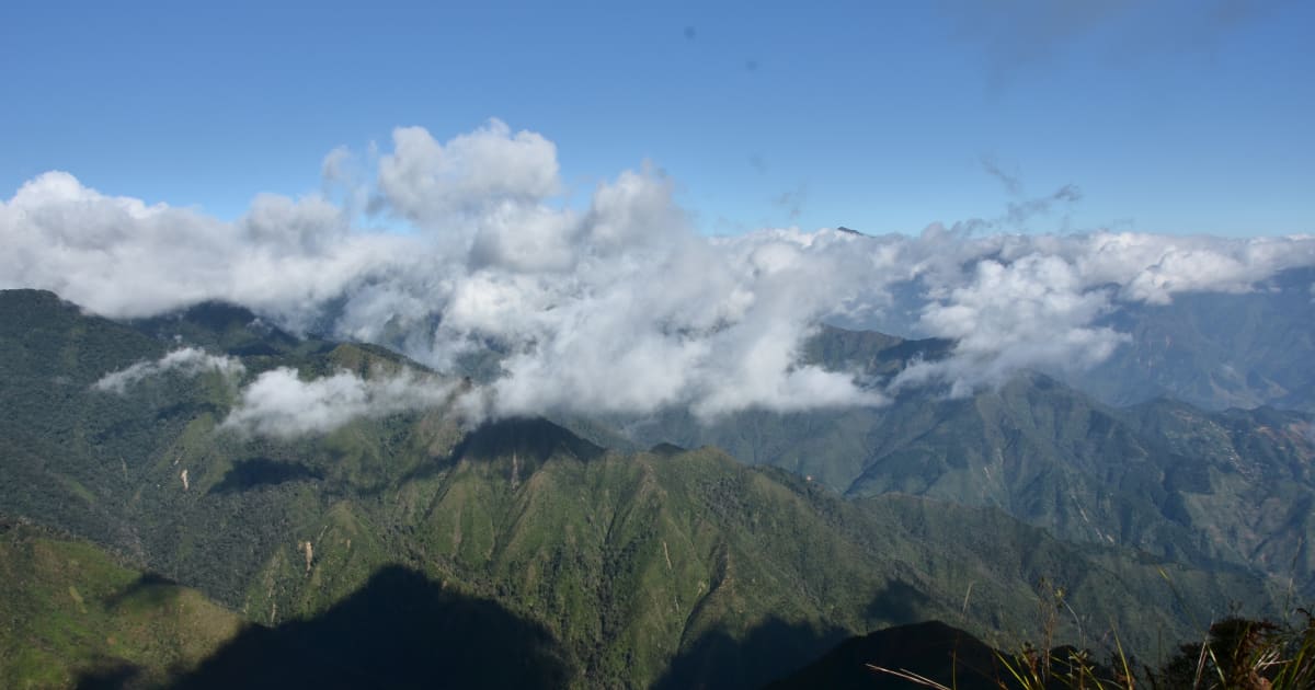
🏔️ Mountain
Ta Năng - Phan Dũng Trek
📍 lam dong, ninh thuan, binh thuan
The Tà Năng - Phan Dũng Trek is the most celebrated multi-day wilderness route in southern Vietnam - a 30-55km crossing through 3 provinces (Lâm Đồng, Ninh Thuận, Bình Thuận) from highland to coast, passing a tri-province peak at 1,701m. Standard format 2 nights 1 day. First opened around 2015.

🎎 Cultural
Tả Van Village
📍 lao cai
Tả Van Village - home of the Giáy people deep in Muong Hoa Valley - is the best homestay base in Sa Pa. Surrounded by sweeping terraced fields, 10km from Sa Pa town, it offers an authentic overnight experience that most visitors to Cat Cat or Fansipan never reach.
🏔️ Mountain
Tà Xùa Mountain
📍 son la, yen bai
Tà Xùa (Phu Sa Phìn) is Vietnam's 13th highest peak at 2,865m, straddling Son La and Yen Bai provinces. The Bac Yen route - the most popular approach - crosses the legendary dinosaur spine ridge above a sea of clouds, passes the iconic turtle rock, and climbs through an ancient moss forest. Standard trek: 2 days, 2 nights, ~23km total.

🏔️ Mountain
Thẩm Mã Pass
📍 ha giang
Thẩm Mã Pass - a lesser-known but stunning mountain pass on the Hà Giang Loop between Yên Minh and Đồng Văn, with sweeping views over terraced valleys and karst peaks that rival the more famous passes.

🏔️ Mountain
Núi Thới Lới
📍 quang ngai
Núi Thới Lới is Lý Sơn's highest point at 169 meters - an extinct volcanic crater where a 20-meter national flag tower stands facing the Hoàng Sa (Paracel) Islands. The summit offers the best panoramic view on the island: garlic fields, fishing villages, Đảo Bé, Hang Câu beach, and open sea in every direction.
🏔️ Mountain
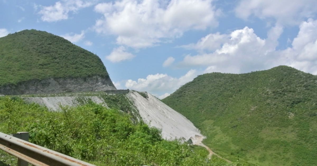
Thung Khe Pass
📍 hoa binh
Thung Khe Pass (Đèo Đá Trắng / White Rock Pass) on National Highway 6 sits at 1,000m with sweeping views of Mai Chau valley and dramatic white limestone cliffs that look like snow from a distance. A mandatory stop on any Hanoi - Mai Chau motorbike route, 100km from Hanoi.

🌿 Nature
Thung Nham Bird Park
📍 ninh binh
Thung Nham Bird Park is a flooded karst valley and wetland in Ninh Bình home to one of northern Vietnam's largest egret and heron colonies - over 40,000 birds nesting in the bamboo forest during breeding season, explored by rowing boat through the flooded valley.
🏝️ Island
Ti Top Island
📍 quang ninh
Ti Top Island - named after Soviet cosmonaut Gherman Titov, who visited with President Hồ Chí Minh in 1962 - is Ha Long Bay's most iconic stop: a crescent-shaped white sand beach for swimming and a 400-step summit climb rewarded with a 360° panorama of the bay.

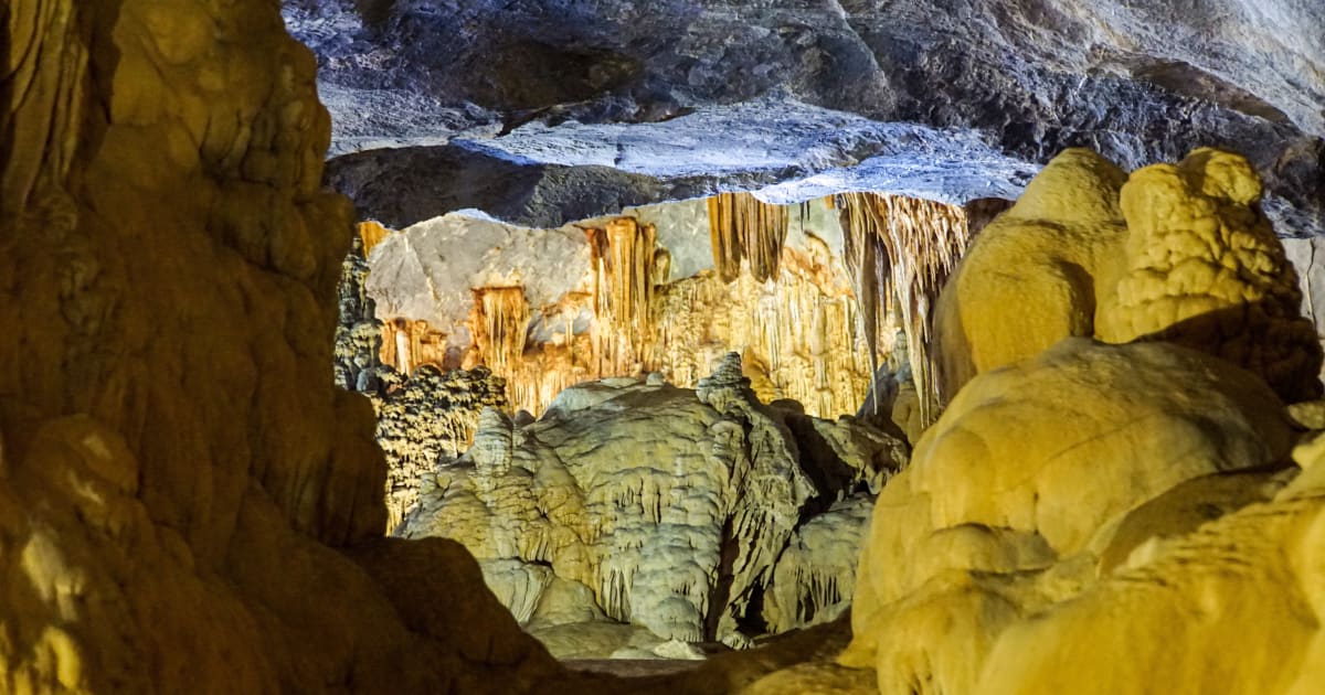
🪨 Cave
Trung Trang Cave
📍 hai phong
Trung Trang Cave is the largest accessible cave on Cát Bà Island - a 300-metre limestone grotto inside the national park with exceptional stalactite and stalagmite formations, a bat colony, and a history stretching from local legend to wartime military use.

🌿 Nature
White Sand Dunes
📍 binh thuan
The White Sand Dunes of Mũi Né are Vietnam's most surreal landscape - vast white dunes stretching to the horizon beside two freshwater lakes, nicknamed the 'Sahara of Vietnam', best experienced at sunrise when the light turns the sand pale gold and the lakes reflect the sky.
🏔️ Mountain
Y Tý
📍 lao cai
Y Tý is a remote Hà Nhì highland commune at 2,000m in Bát Xát district, Lào Cai - one of northern Vietnam's last genuine hidden gems. Famous for sea-of-clouds photography, golden rice terraces, Thác Rồng waterfall, and trekking to peaks like Lảo Thẩn (2,860m), Ky Quan San, and Nhìu Cồ San.
💧 Waterfall
Yavly Waterfall
📍 binh thuan
Yavly Waterfall is a remote cascade deep in the forest along the Tà Năng - Phan Dũng trekking route, one of the most celebrated multi-day wilderness treks in southern Vietnam. Reached only on foot after a full day of hiking through grasslands and primary forest, it is the kind of waterfall that has to be earned.
🌿 Forest
Yên Minh Pine Forest
📍 ha giang
The Yên Minh Pine Forest is an unexpected stretch of highland pine on the Ha Giang Loop between Quản Bạ and Đồng Văn - a 10km section of road through dense Pinus kesiya forest at 1,200 metres, with morning mist threading between the trees and a completely different atmosphere from the surrounding karst landscape.

🏔️ Mountain
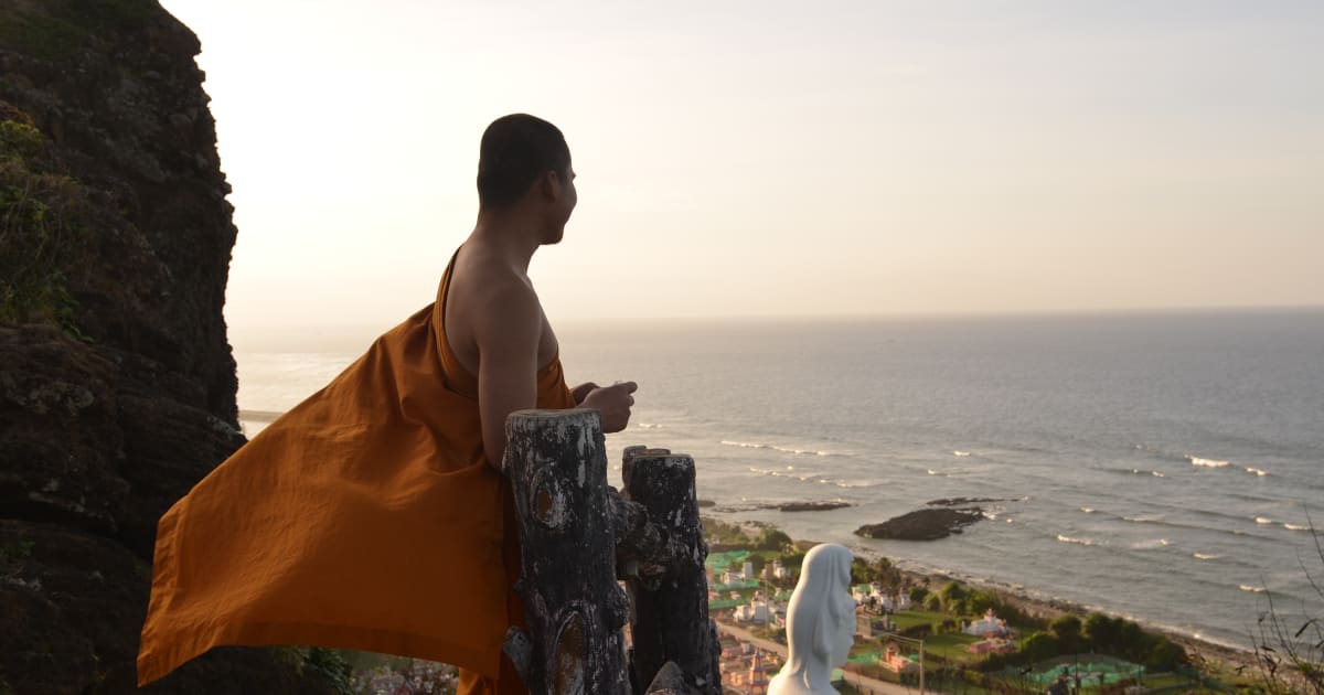
Yên Tử Mountain
📍 quang ninh
Yên Tử Mountain is Vietnam's most sacred Buddhist peak - a 1,068m forested summit in Quảng Ninh where King Trần Nhân Tông abdicated in 1299 to found the Trúc Lâm Zen school. Part of the UNESCO World Heritage complex recognised in July 2025.
Browse other experiences
Beaches37 placesCamping33 placesCaving12 placesSnorkeling19 placesKayaking23 placesFood24 placesCulture117 placesHistory78 placesPhotography239 placesMarkets5 placesNightlife9 placesWalking Tours81 placesCycling36 placesBoat Tours37 placesCable Cars3 placesHomestays9 placesWildlife38 placesMotorcycling31 placesShopping2 places