Menu
DestinationsLocationsBlogMapAbout
mountain · nature · temple

Núi Dinh (Dinh Mountain)

Núi Dinh is a roughly 500m-high mountain range in Bà Rịa–Vũng Tàu province - the highest in the region - with a paved road climbing much of the mountain, forested trails to Đỉnh La Bàn (a former US military helicopter pad and one of the mountain's best-known viewpoints), pagodas including Chùa Hang Mai, and streams with natural swimming pools at Suối Tiên and Suối Đá.

Coastal PeakSummit TrekMultiple PagodasFormer Helicopter Pad
Get Directions
Best Time to Visit
Start early to beat the midday heat, and to have the best chance of clear summit views before any afternoon haze builds
Entry Fee
Free (a parking fee of roughly 10,000-20,000 VND applies at the various trailhead lots)
Opening Hours
Open daily
Address
Mỹ Xuân, Phú Mỹ (formerly Tân Thành district), Bà Rịa – Vũng Tàu
Crowds
Very crowded on weekends; trails are well-marked but heavily trafficked Saturdays and Sundays
Difficulty
Medium difficulty overall; the paved sections are easy, while the remaining trail sections suit beginners with reasonable fitness and proper hiking shoes
Safety
No mobile signal at the summit - arrange a pickup point and time with your driver beforehand. Forest mosquitoes can be more resilient than standard repellent.
Accessibility
A paved road reaches well up the mountain and is motorbike-friendly, with a short walk from parking to the main sights on some routes; steep sections call for good brakes if riding
Seasonal
Visit roughly June-November for the rainy season, when Suối Tiên and Suối Đá are flowing well; March-May is dry season and the streams can run low or dry, though trails are less muddy

What Makes Núi Dinh (Dinh Mountain) Special

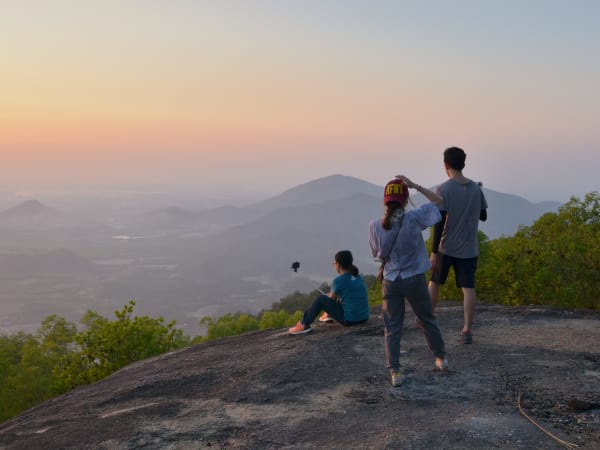
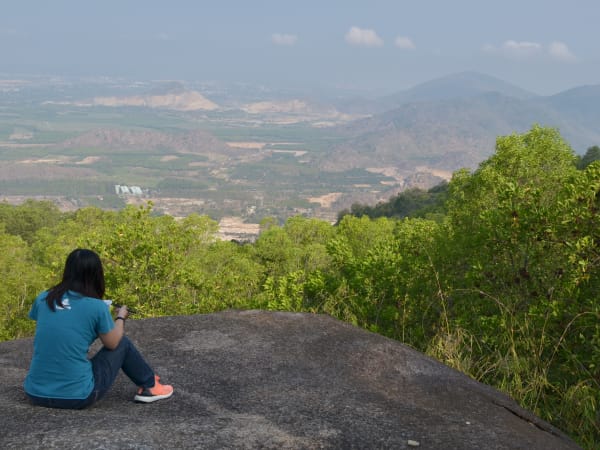
Núi Dinh rises 504 metres from the flat coastal plains of Bà Rịa–Vũng Tàu province, making it the highest peak in the region, spread across what are now Tân Hải, Long Hương, and Châu Pha wards in Phú Mỹ city (formerly Tân Thành district). The mountain is visible as an isolated forested peak from much of the surrounding lowland, roughly 80km from Ho Chi Minh City (about a 2-hour drive), about 30-35km from Vũng Tàu city, and around 13-15km from Bà Rịa's centre. The range's highest point is Núi Ông Trịnh, at 504m, though the mountain's best-known high point among visitors is Đỉnh La Bàn ('Compass Peak'), a large, flat rock outcrop that American forces used as a helicopter landing pad during the war - today it's the mountain's signature viewpoint, sunrise/sunset spot, and most popular campsite, though the flat ground up there is limited, so larger groups need to manage tent space carefully. The mountain has an informal but well-established network of colour-coded trails of varying length and difficulty - roughly a 5km 'Green' route, a 7km 'Blue' route, an 11km 'Yellow' route, and a 13km 'Red' route - linking a scatter of pagodas and landmarks: Chùa Hang Mai (a centuries-old cave pagoda, since rebuilt), Chùa Thiền Tôn Phật Quang (built into a cave over 30 years ago, with a Tam Thế Phật statue weighing more than 10 tonnes), Chùa Hang Tổ, Thiền viện Minh Đức, and streams including Suối Tiên and Suối Đá, which form small, clear, moss-edged pools shaded by forest canopy - a popular cool-off spot when they're running well after rain. Local vendor stalls along the way (referred to by hikers simply as 'cô Kiều', 'cô Hướng', and similar) double as informal trail junctions and rest stops. The mountain's combination of an active pilgrimage site, a wartime history, natural swimming spots, and a genuine choice of routes gives it a richer character than a straightforward hill walk - though the trail network is informal enough that getting lost is a real, well-documented risk despite the mountain's easy reputation.

Getting There

Núi Dinh is located in what's now Phú Mỹ city (formerly Tân Thành district), approximately 80km from Ho Chi Minh City and around 30-35km from Vũng Tàu city. By motorbike from HCMC, take the HCMC–Long Thành–Dầu Giây Expressway, continue onto QL51 toward Bà Rịa–Vũng Tàu, then turn off onto Đường Tránh (the bypass road) toward the mountain, where signage points the way up. A paved road climbs a substantial part of the mountain to a parking area (around 10,000 VND), from which the main sights are a manageable walk away. There is no regular public transport to the trailhead; motorbike or car is the standard approach.

On the Ground

For a light visit, the walk from the parking area to Chùa Hang Mai, Suối Tiên, and Đỉnh La Bàn takes roughly 2-3 hours at a comfortable pace; going deeper into the forest to explore further can take 4-6 hours or a full day. The paved road handles much of the elevation gain, so the walking sections are shorter and less strenuous than a full mountain hike from the base. Along the way, Chùa Hang Mai and Chùa Phật Quang are active pagodas with regular visitors and pilgrims; Suối Tiên and Suối Đá offer shaded, clear pools for a swim when water levels are good (roughly June-November - the streams can run low or dry in the peak dry season of March-May). Đỉnh La Bàn itself is a large, open rock platform with 360-degree views across the province - on clear days you can see the Vũng Tàu peninsula, the Cần Giờ mangrove coast, and the offshore oil platforms in the South China Sea.

Tips

Núi Dinh is well suited to travellers combining a Vũng Tàu beach trip with something more active, or to trail runners and casual trekkers based in Ho Chi Minh City looking for an accessible weekend outing. Because a paved road covers much of the ascent, it's more approachable than its 504m height might suggest - you can drive most of the way and still get a genuine trekking experience on the remaining trail sections. The religious dimension - multiple active pagodas and regular pilgrim traffic - adds cultural texture, and the streams give it an edge over drier hill walks nearby. It gets busy on weekends, so a weekday visit or an early weekend start will make for a much quieter trip.

Based on real traveler experiences and commonly mentioned advice from multiple visitors.

Download an offline map or a hiking app with shared routes before you go - trails are marked with coloured blazes and rope markers in places
Bring insect repellent effective against forest mosquitoes, not just city-strength spray
Pack out all your trash - litter has become a real problem at the summit and affects the local wildlife
Time needed: 2-3 hours for the main highlights (Đỉnh La Bàn, Chùa Hang Mai, Suối Tiên); 4-6 hours or a full day if you want to explore further into the forest
A paved road climbs a good part of the mountain to a parking area, from which it's a short walk (as little as 5 minutes on some routes, longer via the forest trail from Chùa Hang Mai) to Đỉnh La Bàn, the summit rock - you don't need to hike the whole way on foot if you'd rather ride up by motorbike
Đỉnh La Bàn - a large, flat rock outcrop high on the mountain (the range's actual highest point, Núi Ông Trịnh at 504m, is a separate peak) - was used by American forces as a helicopter landing pad during the war, and is now the mountain's best-known viewpoint and most popular photo spot
The trail passes several pagodas, including Chùa Hang Mai (a centuries-old pagoda, since rebuilt) and Chùa Phật Quang - the mountain has real religious significance and sees regular Vietnamese pilgrim traffic
Suối Tiên and Suối Đá, two streams running down the mountainside, form small clear pools good for a cool dip, especially during and after the rainy season (roughly June-November) - they can run low or dry in the peak dry months (March-May)
Views from the summit extend across the Vũng Tàu peninsula and on clear days to the offshore oil platforms in the South China Sea
Mobile signal drops out for most of the trek once you leave the base of the mountain, which has 4G - arrange a pickup point and time with your driver in advance if you're not self-driving the whole way, and don't rely on your phone for navigation without an offline map
Mosquitoes in the forest can be more resilient than standard city-strength repellent - bring a stronger option if you're spending time in the shaded sections
There are actually quite a few small drink and snack vendors scattered around the mountain and along the trails, so you don't need to carry excessive amounts of water - a couple of bottles to start is usually enough
Snakes are a genuine concern, especially in dry grass areas - if camping at the summit, pitch your tent on open dirt or short grass rather than tall dry grass, and consider bringing a trekking pole partly to probe the path ahead
Despite its easy reputation, getting lost on Núi Dinh is a well-documented risk given the informal, multi-route trail network - don't hike alone, download an offline map or app (ExoTrails is a popular choice among local hikers) before you go, and pick up a photo of the route map posted at the parking/motorbike-drop area
Children aged 6 and up can generally manage the trek with parental supervision

Common questions from travelers who've visited this place.

Can I drive to the summit?
A paved road covers a substantial part of the ascent, with a parking area partway up (around 10,000 VND). From there, it's a walk of anywhere from a few minutes to a couple of hours to reach Đỉnh La Bàn and the other main sights, depending on the specific route.
What's the best time to visit for swimming?
Roughly June to November, when rainy-season flow keeps Suối Tiên and Suối Đá's pools topped up. March to May is the dry season and these streams can run low or dry.
Is it safe to hike alone?
It's not recommended - despite the mountain's easy reputation, getting lost is a well-documented risk given the informal, multi-route trail network, and mobile signal drops out for most of the trek above the base. Bring a companion, download an offline map or hiking app beforehand, and let someone know your plans.