Menu
DestinationsLocationsBlogMapAbout
📍 nature · heritage · da nang

Sơn Trà Peninsula

Sơn Trà Peninsula is Đà Nẵng's wild backyard - a 4,439-hectare nature reserve rising directly from the sea, home to one of Vietnam's last populations of the endangered red-shanked douc langur. Known for scenic mountain roads, quiet northern beaches, and Linh Ứng Pagoda with its 67m Lady Buddha.

🐒 Red-Shanked Douc Langur🌿 Nature Reserve🏍️ Scenic Drive📸 Photography
🧭 Get Directions
Best Time to Visit
📅 Mar - Sep (dry season, clear roads, best wildlife sightings). Oct - Feb brings rain and fog; roads can be slippery.
Entry Fee
🎟️ Free
Opening Hours
🕐 Open daily. Best 5:30-9:00 AM for wildlife. Avoid after dark - forest roads are dangerous at night.
Address
📌 Thọ Quang, Sơn Trà, Đà Nẵng
👥Crowds
Lower areas (Linh Ứng Pagoda, Bãi Bắc) get busy on weekends and holidays. The forest road and summit are quieter. Arrive before 7 AM for wildlife and quiet mountain roads.
🥾Difficulty
Easy to moderate. Lower areas are flat and accessible by car or automatic scooter. Upper mountain roads require a manual motorbike or car - steep with sharp bends. Walking trails exist but the main way to explore is by vehicle.
⚠️Safety
Automatic scooters banned on upper roads. Check brakes before ascending - the descent is steep. Don't ride after dark. Macaques on the road - slow down and don't feed them. Stay on established paths in the forest.
🚶Accessibility
Lower attractions (Linh Ứng Pagoda, Bãi Bắc) are accessible by car or automatic scooter. Upper summit road requires manual motorbike or car. Bus 9 serves the lower peninsula. Not suitable for elderly or young children on foot for the upper mountain.
🌤️Seasonal
Mar-Sep: dry season, best overall. Oct-Feb: rain and fog, roads become slippery, wildlife harder to spot. Avoid roads at night year-round.

What Makes Sơn Trà Peninsula Special

Sơn Trà Peninsula juts into the sea northeast of Đà Nẵng, rising to 696 metres at its summit and covering 4,439 hectares of protected nature reserve. The peninsula's position - three sides surrounded by water, the fourth connected to the city by a narrow isthmus - has preserved its forest in a way that almost nothing else near a Vietnamese city has matched. Sơn Trà protects one of the world's largest remaining populations of the red-shanked douc langur - a species often described as one of the most beautiful primates on Earth, vivid orange, black, white and grey with a face that looks almost painted, and listed as endangered. The peninsula's combination of protected status, accessible roads, and proximity to a major city makes it one of the few places anywhere where visitors can observe this species without deep-forest expeditions. The site carries historical weight as well. On 1 September 1858, French and Spanish forces fired the first shots of their invasion of Vietnam from Đà Nẵng Bay, landing at the foot of this peninsula - the moment that opened nearly a century of colonial rule. A former US radar installation from the 1960s, known as Trạm Radar 29 or the 'Eye of Indochina', still stands on the slopes; one of Vietnam's eight oldest lighthouses, built by the French and operational since 1902, marks the peninsula's eastern point.

🚗 Getting There

Sơn Trà Peninsula is approximately 10-15km northeast of Đà Nẵng city centre, accessible by motorbike or car via the coastal road from Mỹ Khê Beach - the peninsula entrance is near Tiên Sa Port. A scenic loop road covers much of the peninsula (approximately 25km total by motorbike, 1.5-2 hours with stops). Motorbike rental in Đà Nẵng: 100,000-150,000 VND/day. Important: automatic scooters (xe tay ga) are banned on upper mountain roads to Đỉnh Bàn Cờ - you need a manual motorbike (xe số) or car to access the summit area. Grab works for lower attractions (Linh Ứng Pagoda, Bãi Bắc) but a motorbike gives flexibility for wildlife areas and the summit road. Bus 9 (Sơn Trà - Hội An route) passes through the lower peninsula.

👀 On the Ground

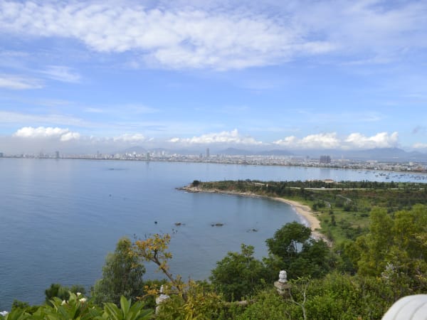
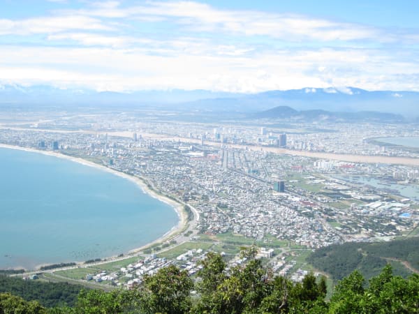
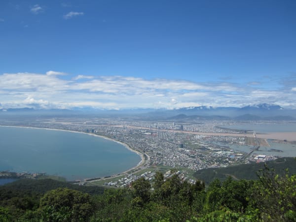
The peninsula divides into three zones. The lower section near the isthmus holds the main road, Linh Ứng Pagoda (home to the 67-metre Lady Buddha statue - the largest in Vietnam, visible from Mỹ Khê Beach across the bay), and several beach access points including Bãi Bắc and Bãi Nam on the quieter northern side. The mid-slopes are dense primary jungle - the best douc langur habitat. Pull over anywhere along the forest road at dawn and scan the canopy; sightings are most likely in the trees directly above the road in the early morning quiet. The summit area (Đỉnh Bàn Cờ, 696m) holds the Trạm Radar 29 former US radar station, a stone chess table and pieces tied to local legend, and panoramic views over Đà Nẵng Bay and the Marble Mountains. The contrast between the wild forest and the resort city visible below is one of Đà Nẵng's most striking visual experiences. Unlike a national park, Sơn Trà has no formal entrance gate or single visitor centre - exploration feels more like driving through a protected mountain than visiting a managed attraction.

🧳 Tips

Sơn Trà is consistently underestimated by visitors who focus on the beach and the bridges. A half-day loop - leaving at 5:30 AM for wildlife, stopping at the summit viewpoint, swimming at Bãi Bắc, finishing at Linh Ứng Pagoda - is one of the best half-days available in any Vietnamese city. It is one of the few places in Southeast Asia where you can leave a modern city after sunrise and be watching endangered primates less than thirty minutes later. Few places in Vietnam also combine colonial history, Cold War relics, Buddhist pilgrimage sites, and endangered wildlife within such a compact area. The douc langurs are the main draw for wildlife travellers; seeing them in the wild is genuinely rare given how few accessible populations remain anywhere. Budget at least half a day; a full day allows a more relaxed pace with swimming and time at multiple stops. Check your motorbike's brakes before heading up - the summit road is steep and narrow with little room for error on the descent.

Based on real traveler experiences and commonly mentioned advice from multiple visitors.

Use a manual motorbike (xe số), not an automatic scooter - the upper road is steep and automatic scooters are banned
Arrive before 6 AM and scan the canopy on the forest road for douc langurs
Half-day minimum: forest → summit → Bãi Bắc → Linh Ứng Pagoda
Don't feed macaques - they bite and will snatch food
Check weather before heading up: fog and rain make the summit road dangerous
Arrive before 6:00 AM for the best chance of seeing red-shanked douc langurs - they're most active at dawn before day-trippers arrive. Pull over anywhere along the forest road and scan the canopy.
Vehicle rules matter: automatic scooters (xe tay ga) are banned on the upper mountain roads leading to Đỉnh Bàn Cờ. They're fine for the lower areas - Linh Ứng Pagoda, Bãi Bắc beach, Ghềnh Bàng. For the summit and upper forest roads, you need a manual motorbike (xe số) or car. Check your rental before heading up.
The road to the summit is 10km of steep, narrow switchbacks - ride slowly, check your brakes before leaving, keep fuel topped up (few stations on the peninsula), and don't switch off the engine going downhill.
Macaques (and sometimes doucs) sit on the road - go slowly and don't feed them. Macaques will grab food and can bite; keep snacks in sealed bags.
Never use drones, loud calls, or flash photography near douc langurs. Stress from repeated disturbance can alter their feeding and resting behaviour - the population's long-term survival depends on minimising human impact.
The peninsula has several distinct stops worth planning around: Linh Ứng Pagoda (Lady Buddha, lower area), Bãi Bắc and Bãi Nam (quiet northern beaches), Trạm Radar 29 (former US radar station from the 1960s, known as 'Eye of Indochina'), Hải Đăng Tiên Sa (Sơn Trà Lighthouse, one of Vietnam's 8 oldest, built by the French and operational since 1902), and Đỉnh Bàn Cờ (summit viewpoint at 696m). Note: Trạm Radar 29 is an active military zone managed by the Vietnamese Air Defence Force - visitors can view it from the road but internal access and photography of the installation are strictly prohibited.
Half-day minimum, full day ideal. A good half-day: leave at 5:30 AM for wildlife on the forest road, continue to the summit viewpoint, swim at Bãi Bắc, finish at Linh Ứng Pagoda.
The legend of Đỉnh Bàn Cờ (Chess Peak): two immortals were said to play chess on this summit. In a fit of anger after losing, one stamped the stone so hard he left a footprint - the mark is called Đá Tiên (Fairy Stone) - then flew back to heaven. The stone chess board and chess pieces remain on the peak today.
Sơn Trà has significant historical weight: on 1 September 1858, French and Spanish forces fired the first shots of their invasion of Vietnam from Đà Nẵng Bay, landing at the foot of the peninsula. It marks the start of almost a century of French colonial rule.
Dress modestly at Linh Ứng Pagoda (covered shoulders and legs). For hiking or forest walking, long sleeves help with insects and sun.
Bring water - the mountain road has no reliable water sources. Sunscreen, a hat, and insect repellent if heading into the jungle.
Bus 9 (Sơn Trà - Hội An route) passes through the peninsula if you want a public transport option to the lower areas, though a motorbike gives far more flexibility.
Don't litter and don't disturb wildlife - the peninsula's forest is one of the few remaining habitats for the douc langur, and its survival depends on minimal human interference.

Common questions from travelers who've visited this place.

Can I use an automatic scooter on Sơn Trà Peninsula?
Partly. Automatic scooters (xe tay ga) are fine for lower areas: Linh Ứng Pagoda, Bãi Bắc beach, and Ghềnh Bàng. They are banned on the upper mountain roads leading to Đỉnh Bàn Cờ summit because of the steep gradient and narrow switchbacks. If your plan includes the summit or the upper forest wildlife areas, rent a manual motorbike (xe số) or go by car. Most rental shops in Đà Nẵng have both types.
What are the chances of seeing douc langurs on Sơn Trà?
Reasonably good if you go early and know where to look. The red-shanked douc langur population on Sơn Trà is estimated at around 1,300 individuals - one of the largest remaining wild populations anywhere. They're most active in the forest canopy in the early morning (before 8 AM) before heat and noise drive them deeper into the jungle. Slow down and scan the treetops along the mid-slope forest road, especially in quiet stretches away from construction or traffic noise. There's no guarantee, but early morning visits in the dry season give a genuine chance.
How long does it take to explore Sơn Trà Peninsula?
Half a day minimum; a full day is better. A tight half-day (5:30 AM to noon): wildlife on the forest road at dawn, summit viewpoint, swim at Bãi Bắc, finish at Linh Ứng Pagoda. A full day allows a slower pace, time at multiple beaches, and a proper look at the historical sites (Radar 29, the lighthouse). The peninsula is only 10-15km from the city centre so it's easy to combine with an afternoon in Đà Nẵng.
Is Sơn Trà Peninsula safe to visit?
Yes, with standard precautions. The main risks are road-related: the upper mountain roads are steep with sharp bends, and automatic scooters aren't appropriate for them. Check your brakes before heading up, ride slowly, and don't attempt the summit road in rain or fog. Macaques on the road are a minor hazard - go slowly and don't feed them. Avoid the forest roads after dark. The lower areas (pagoda, beaches) are straightforward and family-friendly.
Explore more
da nang - Full Guide
View destination guide →