31 places
Motorcycling in Vietnam
The best way to see Vietnam - on two wheels, on your own schedule
31 locations for motorcycling

📍 Landmark
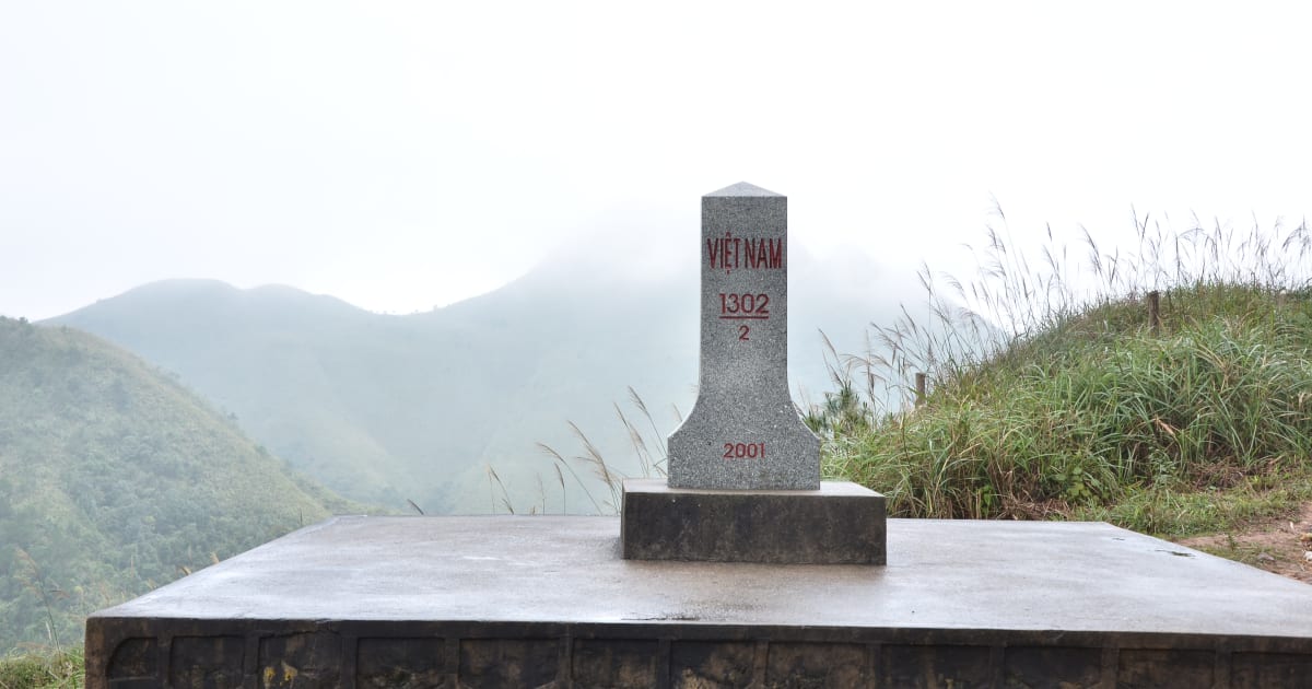
A Pa Chai (Vietnam's Westernmost Point)
📍 dien bien
A Pa Chai is Vietnam's westernmost point - a remote peak in Điện Biên province where the borders of Vietnam, Laos, and China meet at a tri-border marker, reached via Đồn Biên Phòng 317 in Mường Nhé district's Sín Thầu commune.
🏔️ Mountain
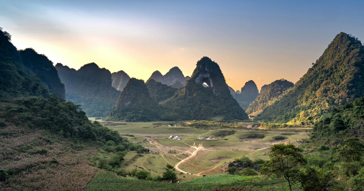
Angel Eye Mountain (God Eye Mountain)
📍 cao bang
Angel Eye Mountain - also known as God Eye Mountain or Núi Thủng - is a limestone karst peak in Cao Bằng with a perfectly circular 50m hole piercing through its summit, set in the Thang Hen valley where the surrounding flatland floods into a 15-hectare lake each rainy season.

🌿 Nature
Bắc Sơn Valley
📍 lang son
Bắc Sơn Valley in Lạng Sơn is a wide basin of patchwork rice paddies ringed by dramatic limestone karst peaks - 80km from Lạng Sơn city, home to Tày, Nùng, and Dao communities in traditional stilt houses. One of northern Vietnam's most photogenic and least-visited valley landscapes.
🏔️ Mountain
Bình Liêu Border Mountains
📍 quang ninh
Bình Liêu in Quảng Ninh is often called a 'mini Sa Pa' - a highland border district with year-round mild climate, ethnic minority villages, and nearly 50km of frontier with China. The border ridge trek to Cột Mốc 1305 crosses the famous dinosaur spine ridge above a sea of reed flowers in October and November.

🏖️ Beach
Bình Sơn Beach
📍 ninh thuan
Bình Sơn Beach in Ninh Thuận is a stretch of undeveloped coastline north of Phan Rang with clear water and a fishing community backdrop - in a province that gets less rain than anywhere else in Vietnam and has some of the most reliably sunny beaches on the south-central coast.

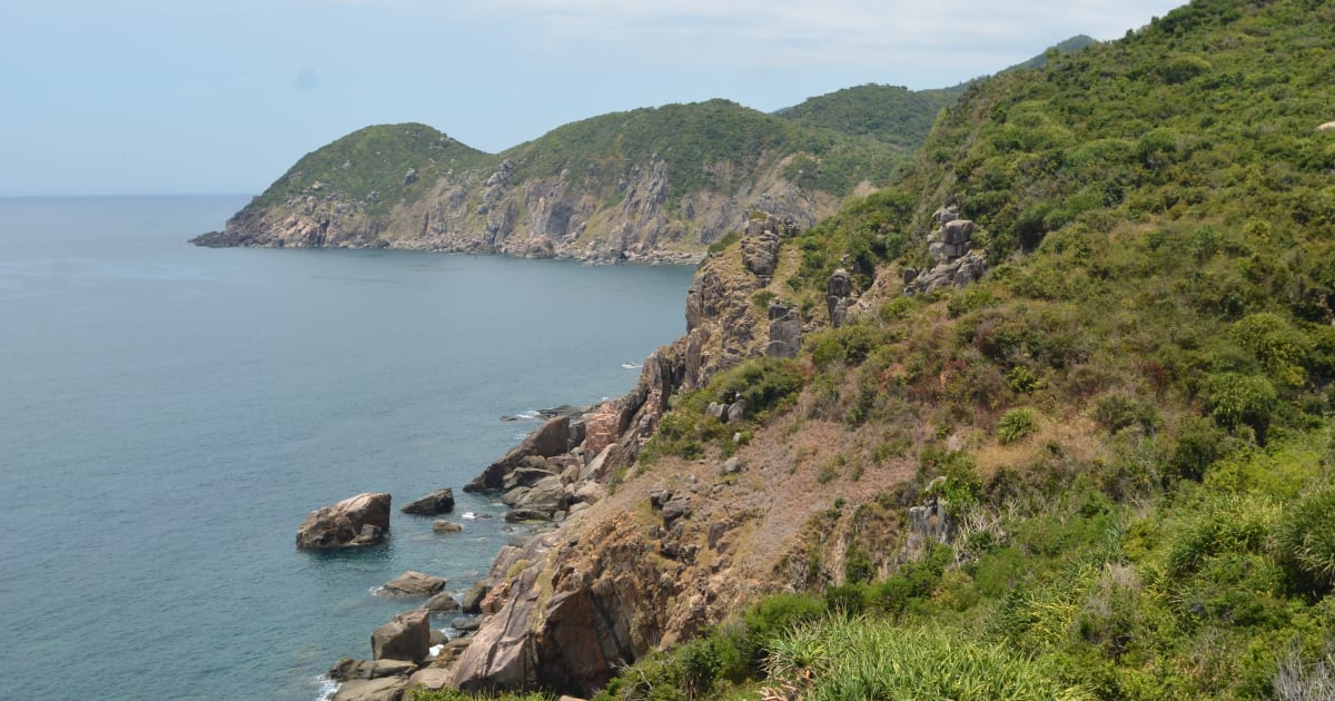
🏖️ Beach
Cape Cà Ná
📍 ninh thuan
Cape Cà Ná is a dramatic headland on the Ninh Thuận coast where granite boulders meet the East Sea against a backdrop of near-desert scrubland - one of the most visually distinctive coastal landscapes on the north-south motorbike route.

🏖️ Beach
Cù Mi Beach
📍 binh thuan
Cù Mi Beach is a largely undeveloped stretch of coastline in Hàm Tân district, Bình Thuận - a quiet fishing community beach that sits between the resort development of Mũi Né to the north and the emerging coast of Hồ Tràm to the south.
💧 Waterfall
Đa Ploa Stream
📍 lam dong
Đa Ploa Stream in Đạ Huoai district of Lâm Đồng is a remote multi-tier Stream in the transitional forest zone between the southern highlands and the lowlands - visited almost exclusively by Vietnamese travelers and largely absent from foreign-language travel content.

🏯 Heritage
Hmong King Palace
📍 ha giang
The Hmong King Palace (Dinh thự họ Vương) in Sà Phìn, Đồng Văn is the former residence of the Vương clan - the most powerful Hmong family in colonial-era Hà Giang - a stone compound built 1898-1907 that blends Hmong, Chinese, and French architectural traditions, funded by control of the plateau's opium trade.

🏝️ Island
Hòn Sơn Island
📍 kien giang
Hòn Sơn is a large mountainous island in the Gulf of Thailand, Kiên Giang - calmer seas and a shorter crossing than Phú Quý, with clear water, Ma Thiên Lãnh peak, fishing villages, and almost no resort development. Minimum 2 nights to do it properly.
🌿 Nature
Khau Cóc Chà Pass
📍 cao bang
Khau Cóc Chà Pass is one of the most dramatic mountain roads in Cao Bằng - a high-altitude route through cloud forest connecting Nguyên Bình to the Phia Oắc massif, with sweeping views over the southern Cao Bằng plateau and valley systems that rival anything on the Ha Giang Loop.

🏔️ Mountain
Khau Phạ Pass
📍 yen bai
Khau Phạ Pass is one of Vietnam's four great mountain passes - a 30km road through the clouds between Tú Lệ and Mù Cang Chải, with the most dramatic views of rice terraces in the country cascading down both sides of the valley below.
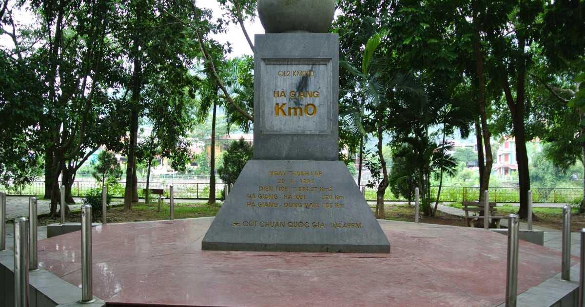
📍 Landmark
Km 0 Milestone — Hà Giang
📍 ha giang
The Km 0 milestone in Hà Giang city centre marks the starting point of National Highway 2 toward the Đồng Văn Karst Plateau - the traditional first stop for motorbike riders before embarking on the Ha Giang Loop, and one of the most photographed check-in spots in northern Vietnam.

🌿 Nature
Lũng Pô
📍 lao cai
Lũng Pô in Bát Xát district, Lào Cai is where the Red River first enters Vietnam from China at border marker 92 - the starting point of one of the two great rivers that built Vietnamese civilization. A 31.43m flagpole (2017) marks the site. Most visited for photography and the symbolic weight of standing at this geographic threshold.
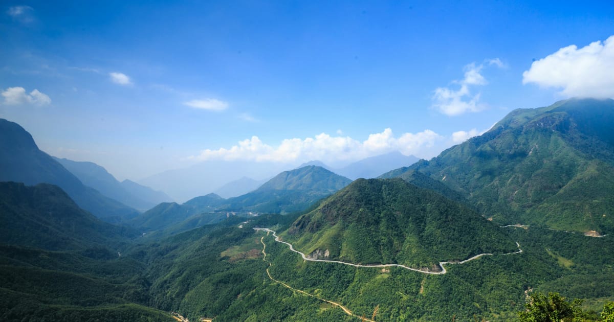
🏔️ Mountain
Mã Pí Lèng Pass
📍 ha giang
Mã Pí Lèng Pass - Vietnam's most dramatic mountain road, a 20km switchback carved into sheer limestone cliffs above the turquoise Nho Quế River canyon. Built 1959-1965 by over 2,000 workers from 16 ethnic groups who hung from ropes on the cliff faces for nearly a year.

🏔️ Mountain
Masara Hill
📍 lam dong
Masara Hill in Đức Trọng district, Lâm Đồng is a 30-hectare expanse of open grassland that turns pink from mid-November to mid-December - one of the few places in Vietnam where this seasonal transformation happens at scale, and largely unknown to foreign visitors.
🏔️ Mountain
Mẫu Sơn Mountain
📍 lang son
Mẫu Sơn is one of the few places in Vietnam where snow falls - a 1,541m massif in Lạng Sơn province near the Chinese border that experiences genuine subalpine conditions in winter, with frost, occasional snowfall, and a sea of clouds that makes it one of the most dramatic landscapes in the northeast.

🌿 Nature
Moc Chau Tea Hills
📍 son la
The Moc Chau Tea Hills are vast rolling plantations of trimmed green tea bushes covering the highland plateau of Son La province, about 10km from Moc Chau town. Most photogenic at dawn when mist settles between the rows - the smell of tea leaves in the cool morning air is one of the defining sensory experiences of the plateau.
🌿 Nature
Mũi Điện (Cape Varella)
📍 phu yen
Mũi Điện (Cape Varella) in Phú Yên is a dramatic 110-metre headland crowned by a working lighthouse - traditionally regarded as the easternmost accessible point of mainland Vietnam, and one of the first places on the country's coastline to receive sunrise.

🏔️ Mountain
O Quy Ho Pass
📍 lao cai, lai chau
Ô Quy Hồ Pass is one of Vietnam's 'tứ đại đỉnh đèo' (four great passes) - the longest mountain pass in the northwest at 50km, crossing the Hoàng Liên Sơn range at 2,035m between Sapa and Lai Châu. Named after the mournful cry of a bird in a tragic love legend.

📍 Landmark
Cầu Ông Cọp
📍 phu yen
Cầu Ông Cọp is Vietnam's longest wooden bridge - an 800-meter hand-built structure of timber and bamboo spanning the Bình Bá river in Phú Yên. Built by locals in 1998 and rebuilt after every flood season, it became famous as a filming location for the 2015 Vietnamese film 'Yellow Flowers on the Green Grass' and is now one of Phú Yên's most photographed landmarks.

💧 Waterfall
Phi Liêng Waterfall
📍 lam dong
Phi Liêng is a 7-tier, 70m waterfall deep in the forest of Đam Rông district, Lâm Đồng - nicknamed 'Tây Nguyên Đệ Nhất Thác' (the greatest waterfall of the Central Highlands). 80km from Đà Lạt, no phone signal inside, a 40-45 degree descent with ropes - genuinely remote and genuinely rewarding.

🏖️ Beach
Phước Bình Beach
📍 vung tau
Phước Bình Beach is a 4km stretch of quiet coastline next to Phước Tĩnh fishing village, tucked behind a row of resorts between Long Hải and Hồ Tràm. Almost no tourist presence - barely shows up in Google search results. Best October to November.

🌿 Nature
Quản Bạ Heaven Gate
📍 ha giang
Quản Bạ Heaven Gate is the first dramatic viewpoint on the Ha Giang Loop - a mountain pass at 1,500 metres where the road crests and the entire Quản Bạ Valley opens below, with the Twin Mountains rising from the valley floor and, in the right season, a sea of clouds filling the basin at dawn.

🏔️ Mountain
Quản Bạ Twin Mountains
📍 ha giang
The Quản Bạ Twin Mountains - Núi Đôi, 'Double Mountains' - are two symmetrical limestone peaks rising from the Quản Bạ Valley floor, an icon of the Ha Giang Loop and the subject of a Tày legend about a fairy who left her twin children behind when she was called back to heaven.
🌿 Nature
Sơn Trà Peninsula
📍 da nang
Sơn Trà Peninsula is Đà Nẵng's wild backyard - a 4,439-hectare nature reserve rising directly from the sea, home to one of Vietnam's last populations of the endangered red-shanked douc langur. Known for scenic mountain roads, quiet northern beaches, and Linh Ứng Pagoda with its 67m Lady Buddha.

🌿 Nature
Ta Pa Fields
📍 an giang
Ta Pa Fields are a landscape of traditional floating rice paddies in the Seven Mountains region of An Giang province, submerged each flood season when the Mekong Delta rises. The combination of water-covered fields, distant mountain silhouettes, and Khmer stilt village architecture makes it one of the most distinctive seasonal landscapes in southern Vietnam.

🏔️ Mountain
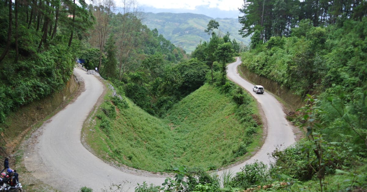
Thẩm Mã Pass
📍 ha giang
Thẩm Mã Pass - a lesser-known but stunning mountain pass on the Hà Giang Loop between Yên Minh and Đồng Văn, with sweeping views over terraced valleys and karst peaks that rival the more famous passes.
🏔️ Mountain
Thung Khe Pass
📍 hoa binh
Thung Khe Pass (Đèo Đá Trắng / White Rock Pass) on National Highway 6 sits at 1,000m with sweeping views of Mai Chau valley and dramatic white limestone cliffs that look like snow from a distance. A mandatory stop on any Hanoi - Mai Chau motorbike route, 100km from Hanoi.
🌿 Nature
Vĩnh Trung Fields
📍 an giang
Vĩnh Trung Fields in Tịnh Biên district stretch across the flatlands beneath the Thất Sơn mountain range - a pastoral landscape of rice paddies, Khmer pagodas, and water buffalo with the dramatic profile of Núi Cấm rising from the plain.
🌿 Forest
Yên Minh Pine Forest
📍 ha giang
The Yên Minh Pine Forest is an unexpected stretch of highland pine on the Ha Giang Loop between Quản Bạ and Đồng Văn - a 10km section of road through dense Pinus kesiya forest at 1,200 metres, with morning mist threading between the trees and a completely different atmosphere from the surrounding karst landscape.
Browse other experiences
Beaches37 placesTrekking78 placesCamping33 placesCaving12 placesSnorkeling19 placesKayaking23 placesFood24 placesCulture117 placesHistory78 placesPhotography239 placesMarkets5 placesNightlife9 placesWalking Tours81 placesCycling36 placesBoat Tours37 placesCable Cars3 placesHomestays9 placesWildlife38 placesShopping2 places