Menu
DestinationsLocationsBlogMapAbout
📍 mountain · forest · nature

Ta Năng - Phan Dũng Trek

The Tà Năng - Phan Dũng Trek is the most celebrated multi-day wilderness route in southern Vietnam - a 30-55km crossing through 3 provinces (Lâm Đồng, Ninh Thuận, Bình Thuận) from highland to coast, passing a tri-province peak at 1,701m. Standard format 2 nights 1 day. First opened around 2015.

🥾 Multi-day Trek🏕️ Camping🌄 Highland to Coast📸 Photography
🧭 Get Directions
Best Time to Visit
📅 Late Jan - early Mar (golden grass, dry, not too hot). Aug - Oct for green grasslands (rainy season - monitor weather carefully).
Entry Fee
🎟️ Free (tour packages typically 1,500,000 - 3,000,000 VND/person for 2N1D with guide, porter, meals)
Opening Hours
🕐 Multi-day trek. Standard format: 2 nights 1 day.
Address
📌 Tà Năng, Đức Trọng, Lâm Đồng to Phan Dũng, Tuy Phong, Bình Thuận
👥Crowds
Popular route with multiple operators running regular departures. Busiest Dec-Apr dry season. Green grass season (Aug-Oct) is less crowded.
🥾Difficulty
Moderate to challenging. Long distance (30-55km), varied terrain, river crossings. Average elevation ~1,100m with peaks to 1,701m. Now well-supported with xe ôm, porters, clear trail - accessible for fit beginners with a guide. Do not attempt alone.
⚠️Safety
River crossings are the primary hazard - multiple fatalities from being swept away. Never cross in heavy rain. Getting lost and waterfall falls have also caused accidents. Book through an established operator with guide. Do not solo.
🚶Accessibility
Tour packages from Đà Lạt operators: toongadventure.vn, bitour.vn, itrek.vn, NowTrip. Xe ôm forest motorbike assistance available on steep sections. Porter services available. Standard format 2N1D.
🌤️Seasonal
Jan-May (mùa cỏ cháy): golden-brown grassland, dry, best late Jan to early Mar. Jun-Dec (mùa cỏ xanh): green grassland, rainier, best Aug-Oct. Rainy season: muddy trails, check weather carefully, avoid heavy rain days for river crossings.

What Makes Ta Năng - Phan Dũng Trek Special

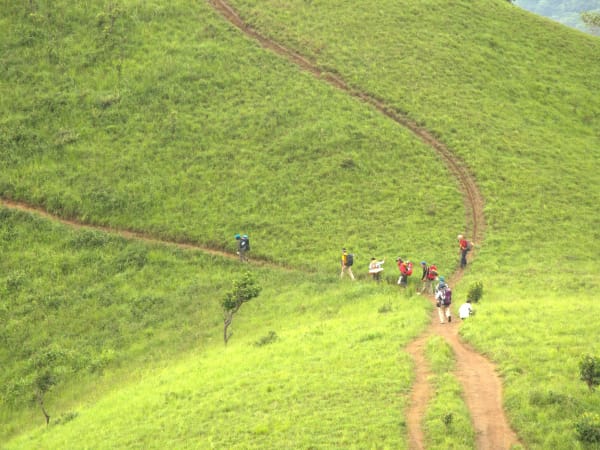
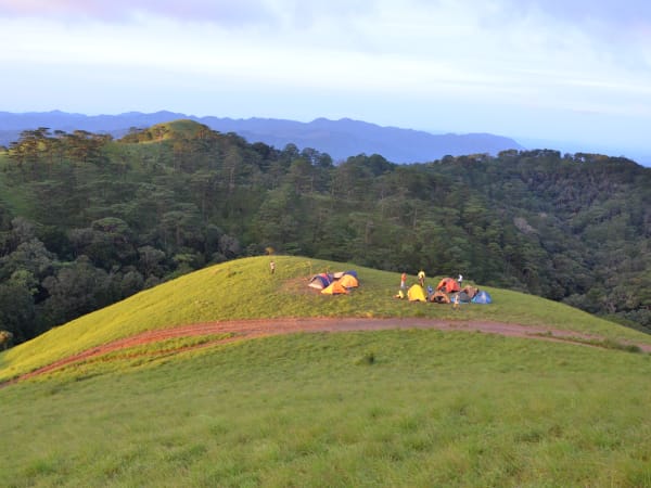
Tà Năng - Phan Dũng is consistently ranked the most beautiful multi-day trek in southern Vietnam - a 30-55km route that crosses terrain from the cool Lâm Đồng highland plateau to the warm Bình Thuận coast, passing through three provinces and a tri-province peak at 1,701m. The route was pioneered around 2015 by motorbike adventurers following logging trails through the forest; it has since grown into one of the most established trekking routes in southern Vietnam, with clear trail markers, xe ôm forest motorbike support, porter services, and multiple tour operators running regular departures. The landscape changes dramatically from start to finish: open grassland and pine forest at the highland entry, a transition zone of river valleys and mixed forest in the middle, and warm lowland vegetation at the Phan Dũng exit. In the dry season (Jan-May) the grasslands burn golden-brown; in the rainy season (Jun-Dec) they turn vivid green. Both have their own visual character.

🚗 Getting There

The standard approach from Ho Chi Minh City is by overnight sleeper bus (Thành Bưởi, Phương Trang) on QL20, dropped at Ngã Ba Tà Hine junction in Đức Trọng, Lâm Đồng - arriving around 3-4 AM. Trekkers rest at local transit houses or homestays in Tà Hine, have breakfast, then take xe ôm or truck into the Tà Năng forest edge trailhead to depart Saturday morning. Going up to Đà Lạt city first and coming back down to the trailhead is unnecessary - it adds time and goes against the route direction. The exit at Phan Dũng village (Tuy Phong district, Bình Thuận) requires pre-arranged transport to Phan Thiết city - about 2 hours by road. Arrange this before departure. Tour packages from Đà Lạt operators (toongadventure.vn, bitour.vn, itrek.vn, NowTrip) handle logistics including trailhead transfers.

👀 On the Ground

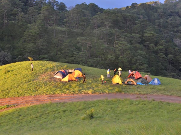
The terrain transitions through distinct zones. The initial section from the Tà Năng forest edge is relatively flat with grassland and scrub. The route then enters shaded forest with continuous climbing. Beyond the forest, the landscape opens to wide savannah-like grassland, rolling ridgelines resembling dinosaur spines, and steep inclines - peaks reach 900-1,100m in this section before the tri-province peak at 1,701m. The descent toward Phan Dũng drops to around 500m through lowland forest. River crossings occur throughout - knee to thigh depth in dry season, potentially dangerous in wet season. Nomadic cattle herders maintain temporary camps in the grassland sections. Night camps are in forest or at water sources. The physical demand is significant but manageable for fit trekkers on the well-supported current route.

🧳 Tips

Tà Năng - Phan Dũng is the benchmark multi-day trek for the southern half of Vietnam. Despite its reputation for difficulty, the current level of trail infrastructure and support services means a person with average fitness and no serious health issues can complete it - especially with a guide and porter. First-timers should book through an established operator. The most important variable is weather: check the forecast before departure, and never push through river crossings in heavy rain. The two seasonal visual experiences (golden grass Jan-Mar, green grass Aug-Oct) are different enough that experienced trekkers sometimes do the route twice. For a longer challenge, the route passes a 3-province boundary marker at 1,701m - one of the more unusual geographical landmarks on any trek in Vietnam.

Based on real traveler experiences and commonly mentioned advice from multiple visitors.

Book through established operators: toongadventure.vn, bitour.vn, itrek.vn, NowTrip
Do not attempt alone - guide essential for river crossings and navigation
Late Jan to early Mar for golden grass; Aug-Oct for green grasslands
Pack light: anti-slip shoes, windproof jacket, rain poncho, energy snacks, enough water for overnight
Arrange Phan Dũng pickup transport before departing the trailhead
The route crosses terrain across 3 provinces: Lâm Đồng, Ninh Thuận, and Bình Thuận, passing a tri-province peak at 1,701m. Total distance 30-55km depending on route chosen.
Standard format is 2 nights 1 day. One-day completions (29km, 5 AM - 6 PM) are possible but extremely tiring.
The route was first opened around 2015 by motorbike teams following logging trails. Now well-established with clear trail markers, xe ôm (forest motorbike) support, porters, and guide services. Accessible for fit beginners.
Book through a reputable operator: toongadventure.vn, bitour.vn, itrek.vn, NowTrip. Do not attempt alone - the route passes waterfalls and fast-flowing streams where accidents (getting lost, falling, being swept away) have occurred.
Two distinct seasonal experiences: mùa cỏ xanh (Jun-Dec, green grasslands, cooler) and mùa cỏ cháy (Jan-May, golden-brown burned grass, more dramatic and photogenic). Best golden grass: late Jan to early Mar. Best green grass: Aug-Oct.
Rainy season trekking (Jun-Oct): trail becomes muddy and slippery. Still doable but check weather forecast carefully before departing. Avoid days with heavy rain - river crossings become dangerous.
⚠️ River crossings are the main hazard. Multiple fatalities have occurred on this route from people being swept away. In dry season these are knee to thigh depth; in rain they rise fast. Stay alert near water.
Clothing and gear: windproof jacket (nights are cold at 1,100m average elevation), anti-slip hiking shoes, light pack, hat, rain poncho, umbrella.
Bring energy snacks: chocolate, candy, energy bars - useful for the long climbs. Carry enough water for 2 people overnight.
Xe ôm (forest motorbike) services are available to assist on steep sections if needed.
Arrange transport pickup at Phan Dũng village before departure - remote exit point, no regular transport.

Common questions from travelers who've visited this place.

Is the Tà Năng - Phan Dũng Trek worth it?
If you're looking for the most iconic multi-day trek in southern Vietnam, yes. The route combines open grasslands, mountain ridges, river crossings, camping, and a genuine sense of wilderness rarely found this close to Ho Chi Minh City. The landscape shifts dramatically from highland pine forest to savannah-like grassland to lowland jungle over 2-3 days - no other trek in the south covers this much terrain variety. Come prepared, book through a reputable operator, and don't rush it into one day.
Can beginners do the Tà Năng - Phan Dũng Trek?
Yes, with proper support. The route now has clear trail markers, xe ôm forest motorbike assistance on steep sections, porter services, and experienced guides. Someone with average fitness and no serious health issues can complete it - especially on a guided tour. The key is not attempting it alone and not pushing through dangerous river crossings in rain.
When is the best time to trek Tà Năng - Phan Dũng?
Two distinct windows: late January to early March (mùa cỏ cháy) for golden-brown burned grassland - dry, not too hot, the most photogenic season. August to October (mùa cỏ xanh) for vivid green grasslands - rainier but lush. Both have their own visual character. Avoid trekking during heavy rain regardless of season - river crossings become dangerous.
How long does the trek take?
Standard format is 2 nights 1 day covering 30-55km depending on route. One-day completions (29km, departing 5 AM, finishing around 6 PM) are possible but extremely tiring for most people. Most operators run 2N1D packages.
What are the main safety risks?
River crossings are the primary hazard - multiple fatalities have occurred from people being swept away, and water levels rise rapidly in rain. Getting lost and falls near waterfalls have also caused accidents. Book through a reputable operator, never go alone, and do not attempt river crossings in heavy rain.
Which operators run this trek?
Established operators running regular departures: toongadventure.vn, bitour.vn, itrek.vn, NowTrip. All include guide, porter, camping gear, and meals in their 2N1D packages.