Menu
DestinationsLocationsBlogMapAbout
📍 nature · forest · landmark · heritage

Mũi Cà Mau National Park

Mũi Cà Mau National Park is the southernmost point of Vietnam's mainland - a UNESCO Biosphere Reserve of 42,000 hectares of mangrove forest at the tip of the Cà Mau Peninsula, where the East Sea meets the Gulf of Thailand. The only place in Vietnam to watch both sunrise and sunset from the same spot.

🗺️ Southernmost Point of Vietnam🌿 Mangrove Forest🐦 Wildlife🚤 Boat Tour
🧭 Get Directions
Best Time to Visit
📅 Dec - Apr (dry season; accessible by road and boat, clearest skies for sunrise/sunset)
Entry Fee
🎟️ 90,000 VND per person
Opening Hours
🕐 7:00 - 17:00 daily
Address
📌 Đất Mũi, Ngọc Hiển, Cà Mau
👥Crowds
Day-trippers from Cà Mau city arrive mid-morning and clear out by early afternoon; staying overnight gives access to the sunrise boat tour and a quieter experience overall
🥾Difficulty
Easy terrain - flat walking trails and boat tours; the main consideration is travel time (100km from Cà Mau city by road, or 2.5-3 hours by boat)
⚠️Safety
Respect the GPS 0001 monument - don't climb on or stand on the marker; bring sun protection for the open boat sections and the coastal monument area
🚶Accessibility
Road access now fully available (bus from Cà Mau's Năm Căn station ~100,000 VND, or motorbike); boat access from Cà Mau city also available; basic guesthouses on-site; limited food options so bring snacks or budget for the park restaurant
🌤️Seasonal
Dry season Dec-Apr for best conditions; wet season May-Nov brings heavy rain and rougher coastal conditions but the mangrove forest is accessible year-round

What Makes Mũi Cà Mau National Park Special

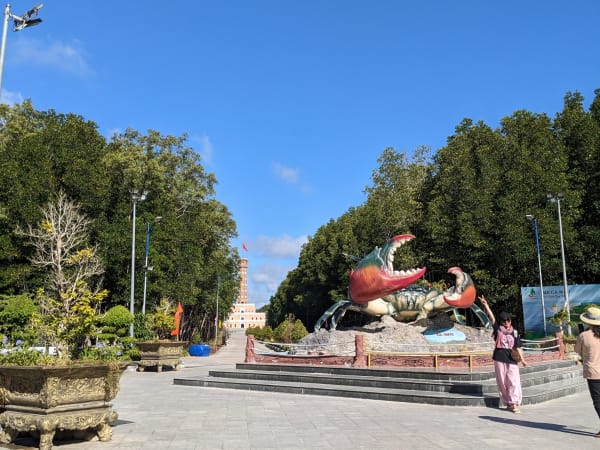
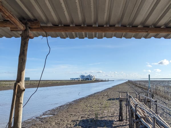
Đất Mũi - the tip of the Cà Mau Peninsula - is the southernmost point of Vietnam's mainland, where the East Sea and the Gulf of Thailand converge at a low coastline of mangrove and tidal mudflat. The national park protecting this area covers 42,000 hectares and is a UNESCO Biosphere Reserve, but what draws visitors here is only partly ecological. This is also a place of considerable symbolic weight: the GPS 0001 national coordinate monument marks the official end of the country's territory; the Ho Chi Minh Road terminus marker records the southern endpoint of the highway that runs the length of Vietnam; and the Hanoi Flag Tower replica - inaugurated in 2019 and modeled on the original at Thăng Long Citadel - embodies the idea of national unity from one end of the country to the other. A famous Vietnamese poem captures the feeling: 'My homeland is like a ship / And its bow is Mũi Cà Mau.' The ship monument on the coast - moved seaward in 2019 as the land itself advanced - is built from that image.

🚗 Getting There

Đất Mũi is approximately 100km from Cà Mau city. Road access has improved significantly and the route is now fully driveable - the most common approach is by bus from Cà Mau's Năm Căn bus station (Trường Giang or Đen Mập services, approximately 100,000 VND per person), or by motorbike along Highway 1. The older boat-only access is still available and remains the more atmospheric option - speedboats from Cà Mau city take 2.5-3 hours through the mangrove canal network. Cà Mau city itself is 350km from Ho Chi Minh City (6-7 hours by road) or 55 minutes by domestic flight.

👀 On the Ground

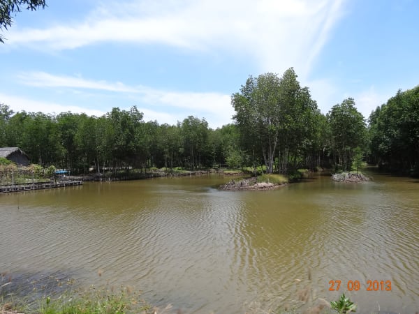
The monument area clusters several landmarks within walking distance: the GPS 0001 coordinate marker, the Ho Chi Minh Road terminus, the Hanoi Flag Tower replica, and the ship monument on the coast. Most visitors spend time at each of these before joining a boat tour through the mangrove canals - small wooden boats that push into the forest interior, canopy closing overhead, the water dark and tannin-stained. The canal tour reveals stilt-house fishing communities and the sensory experience of being inside a mangrove forest: close, quiet, the smell of mud and saltwater, occasional kingfishers and wading birds. For those staying overnight, the sunrise boat tour departing at 5 AM is the standout activity - the only place in Vietnam where both sunrise and sunset are visible from the same point.

🧳 Tips

Đất Mũi works as a day trip from Cà Mau city but a night there changes the experience. The day-trip crowd arrives mid-morning, photographs the monuments, and leaves by early afternoon - staying overnight means having the canal tours, the sunrise, and the mangrove trails in relative quiet. The dry season (December to April) gives reliable conditions for the boat tours and the open coastal sections; the wet season (May to November) makes the journey muddier and the coastal views less reliable, though the forest itself stays lush year-round.

Based on real traveler experiences and commonly mentioned advice from multiple visitors.

Book the sunrise boat tour (800,000 VND/boat, departs 5 AM) the evening before through your guesthouse - this is the most memorable activity at Đất Mũi and requires an overnight stay
The mangrove canal boat tour is separate from the monument visit - arrange it on arrival and allow 1.5-2 hours; the inner channels are where the forest experience actually happens
Don't stand on or climb the GPS 0001 coordinate marker - it's a national sovereignty monument and Vietnamese visitors take it seriously
The GPS 0001 national coordinate monument is the emotional core of the visit - the official southernmost point of Vietnam's mainland, marking territorial sovereignty; treat it with respect and don't stand on the marker
Đất Mũi is the only place in Vietnam where you can watch both sunrise over the East Sea and sunset over the Gulf of Thailand from the same location - rent a boat (800,000 VND/boat) for the sunrise tour starting at 5 AM
The ship monument (biểu tượng con tàu) was relocated further seaward in 2019 - the Mekong's sediment deposits push the coastline 50-80 meters further south every year, so the 'end of Vietnam' literally moves
The mangrove canal boat tour is the second half of the experience - small wooden boats thread through the mangrove canopy where sunlight doesn't reach the water, past stilt-house communities and into the deeper forest sections
Stay overnight - Đất Mũi now has basic guesthouses with decent facilities, and having the morning to yourself before day-trippers arrive is worth it; the sunrise boat tour alone justifies the extra night

Common questions from travelers who've visited this place.

How do I get from Cà Mau city to Đất Mũi?
Two options: by bus from Cà Mau's Năm Căn bus station (Trường Giang or Đen Mập services, ~100,000 VND, road now fully paved), or by speedboat through the mangrove canals (2.5-3 hours, more atmospheric). Road access has improved significantly in recent years - the boat-only era is over.
What are the main landmarks at Đất Mũi?
Four key monuments cluster together: the GPS 0001 national coordinate marker (southernmost point of Vietnam's mainland), the Ho Chi Minh Road terminus marker, the Hanoi Flag Tower replica (inaugurated 2019, modeled on the Thăng Long Citadel original), and the ship monument on the coast - all within walking distance of each other.
Why does the southernmost point keep moving?
The Mekong River deposits sediment that extends the Cà Mau coastline 50-80 meters further south every year. The ship monument was already relocated seaward in 2019 to reflect the advancing land. The GPS 0001 marker records the official registered coordinate rather than a fixed geographic point.