Menu
DestinationsLocationsBlogMapAbout
📍 waterfall · nature · forest · da lat

Phi Liêng Waterfall

Phi Liêng is a 7-tier, 70m waterfall deep in the forest of Đam Rông district, Lâm Đồng - nicknamed 'Tây Nguyên Đệ Nhất Thác' (the greatest waterfall of the Central Highlands). 80km from Đà Lạt, no phone signal inside, a 40-45 degree descent with ropes - genuinely remote and genuinely rewarding.

💦 7-Tier Waterfall🌿 Remote Forest Trek🏍️ Motorbike Trail📸 Photography
🧭 Get Directions
Best Time to Visit
📅 Late Nov - Apr (dry season: manageable trails, clear streams, campable base). Rainy season (Jun-Nov) for maximum water volume but treacherous descent.
Entry Fee
🎟️ Free (may need to pass through forest protection station)
Opening Hours
🕐 Open daily. Day trip possible but depart early from Đà Lạt.
Address
📌 Phi Liêng, Đam Rông, Lâm Đồng
👥Crowds
Almost no other visitors on weekdays. Mainly local people working in the forest. Genuinely remote - no tourist infrastructure.
🥾Difficulty
Challenging. The descent to the base is 40-45 degrees with rope assistance, approximately 70m. Slippery in all seasons, extremely dangerous in rainy season when spray keeps the path wet year-round. Pack light - heavy bags increase fall risk significantly.
⚠️Safety
No phone signal inside forest - download offline maps before entering. Go in a group; hire a local guide if unfamiliar with forest navigation. Flash flood risk April-June if camping near the stream. Swimming: cold water year-round, afternoon only, life jacket required in the pool. Do not descend or ascend with a heavy pack.
🚶Accessibility
80km from Đà Lạt, 2-2.5 hours by motorbike. Can park at forest protection station and walk 5km in. No facilities at the falls - bring all food, water, and equipment.
🌤️Seasonal
Late Nov-Apr: dry season, best for trekking and camping. Jun-Nov: rainy season, maximum water volume but extremely slippery descent and flash flood risk. Apr-Jun transition: especially dangerous for flash floods if camping.

What Makes Phi Liêng Waterfall Special

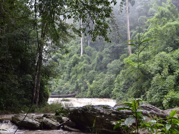
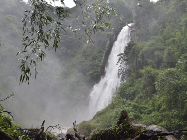
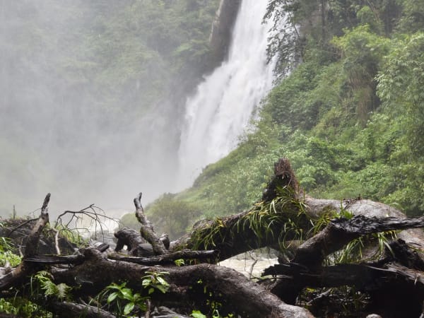
Phi Liêng Waterfall - nicknamed Tây Nguyên Đệ Nhất Thác, the greatest waterfall of the Central Highlands - is a 7-tier cascade dropping over 70m through primary and secondary forest in Đam Rông district of Lâm Đồng province, about 80km from Đà Lạt. The waterfall is fed by streams draining the highland plateau and flows through K'Ho minority community territory where almost no foreign visitors reach. The approach passes forest protection checkpoints, K'Ho villages, and coffee farms before the trail enters the forest and the phone signal disappears. The descent to the waterfall base is the most physically demanding section - a 40-45 degree slope with rope assistance dropping around 70m. Below the falls, a clear pool suitable for swimming in the dry season and a flat campable area make it a genuine destination for those willing to earn it.

🚗 Getting There

Phi Liêng is approximately 80km from Đà Lạt city - about 2 to 2.5 hours by motorbike. The standard route goes via Highway 27 through Nam Ban (Lâm Hà) and Đinh Văn (Đức Trọng) before turning into Đam Rông district toward Phi Liêng commune. Do not take the Lạc Dương road (ĐT722) - that route heads deep into Bidoup forest or toward Đắk Lắk and is not the right approach. Download offline maps before departing - GPS becomes unreliable in the forest interior and there is no phone signal past a certain point. You can ride to the forest protection station and park there, then walk in approximately 5km - recommended if road conditions are wet. A high-clearance motorbike handles the rough sections better than a scooter. Ask locally in Đam Rông town for current trail conditions.

👀 On the Ground

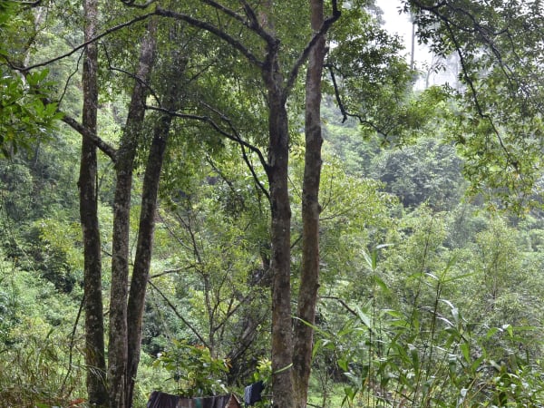
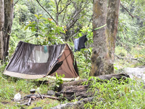
The approach through Đam Rông is the cultural dimension of the trip - K'Ho stilt house villages, highland coffee forest, and a landscape entirely unlike the tourist Đà Lạt plateau. The trail to the falls passes through dense forest with few other visitors - mostly local people working their fields. At the waterfall, seven distinct tiers drop over basalt and granite formations with a base pool that is cold and clear in the dry season. The hardest moment is the final descent: 40-45 degrees, rope-assisted, 70m. Once at the base, the scale of the waterfall is impressive - the noise and spray fill the enclosed forest bowl. About 1.2km downstream, a flat sandbar island in the middle of the river makes an alternative camping spot.

🧳 Tips

Phi Liêng is for travelers who have done the standard Đà Lạt waterfall circuit and want something that requires genuine commitment. The remoteness here is not staged - there is no phone signal, the descent is physically serious, and the trail has real navigation challenges. Go in a group, go in dry season, download offline maps, pack light, and move slowly. The reward is a 7-tier, 70m waterfall in intact Central Highlands forest that most people in Đà Lạt have never heard of. Day trip from Đà Lạt is possible but an overnight camp at the base - with fishing, the sound of the falls, and cold forest air - is the full experience.

Based on real traveler experiences and commonly mentioned advice from multiple visitors.

Download offline maps before entering - no signal in the forest, multiple branching trails
Go in a group and pack light - the 40-45 degree descent is serious
Dry season (Nov-Apr) for trekking; avoid camping April-June due to flash flood risk
Park at forest protection station and walk 5km in if road is muddy
Swimming: afternoon only, wear a life jacket, water is cold year-round
Download offline maps before you go - there is no phone signal inside the forest, and the trail has multiple branching paths that are easy to confuse. Google Maps is useless once you're in.
Go in a group. The terrain is serious and having people with you matters on the steep descent. If you have no forest experience, hire a local guide from Đam Rông or Phi Liêng commune - getting lost here is a real possibility.
The hardest section is the descent to the waterfall base - a 40-45 degree slope dropping about 70m with ropes installed for gripping. Take it slowly, one step at a time. Do not rush and do not overload your pack - a heavy bag will drag you down if you slip.
The road can get muddy and slippery. You can leave your motorbike at the forest protection station and walk in about 5km - safer than riding through the worst sections.
In rainy season, moisture from the waterfall spray keeps the descent path permanently wet even on sunny days, combined with decomposing leaves - extremely slippery. The dry season descent is already demanding; rainy season adds serious injury risk.
Watch the weather if camping. April, May, June are particularly dangerous for flash floods - heavy rain upstream sends water surging down quickly. Check forecasts and don't camp near the stream if rain is expected.
Swimming: water is cold year-round. Only swim in the afternoon, not in the evening. Always wear a life jacket when entering the waterfall pool.
Camping options: a flat area at the waterfall base, or a larger sandbar about 1.2km downstream. Both work in dry season.
Camping overnight: bring sleeping mat, folding bed, blanket, warm clothes, and a heat lamp - the base of the falls is genuinely cold at night.
Fishing is possible in the calmer pools downstream - bring gear and cooking equipment for fresh fish at the camp.
Move slowly over the stream crossings - algae on the rocks makes them slippery. Slow feet beat fast falls.
Insect repellent is essential. Pack light - every unnecessary kilogram matters on the descent.
Do not litter in the forest.
Day trip from Đà Lạt is possible (80km, 2-2.5 hours) but depart early.

Common questions from travelers who've visited this place.

How hard is the trek to Phi Liêng Waterfall?
The approach trail is moderate but the descent to the waterfall base is genuinely challenging - a 40-45 degree slope dropping about 70m with rope assistance. Slippery in dry season, extremely dangerous in rainy season when the falls' spray keeps the path permanently wet. Pack light; a heavy bag significantly increases fall risk. Take it slowly and don't rush the descent.
Can I visit without a guide?
Technically yes, but not recommended without forest experience. The trail has multiple branching paths that are easy to confuse, there is no phone signal inside, and getting lost is a real possibility. If unfamiliar with forest navigation, hire a local guide from Đam Rông commune or arrange through local contacts in Đà Lạt.
When is the best time to visit?
Late November to April - dry season, manageable trail conditions, streams crossable, campable base. Rainy season (Jun-Nov) gives the most dramatic water volume but the descent becomes extremely slippery and dangerous. April to June is the most dangerous period for camping due to flash flood risk from upstream rain.
Can I camp at Phi Liêng?
Yes - flat ground at the waterfall base, or a larger sandbar island about 1.2km downstream. Dry season camping only; avoid April-June when upstream rain can cause sudden flash floods. Bring sleeping mat, blanket, warm clothes, and a heat source - nights at the base are cold. Fishing in the downstream pools is possible.
Explore more
da lat - Full Guide
View destination guide →