Menu
DestinationsLocationsBlogMapAbout
📍 lake · nature

Tà Đùng Lake

Tà Đùng Lake in Đắk Nông is called the 'Hạ Long Bay of the Central Highlands' - a reservoir with 47+ forested islands that are actually the hilltops of submerged terrain, formed by the Đồng Nai 3 hydroelectric dam. Sea of clouds visible at 5-6 AM during rainy season. 250km from Saigon.

⛵ Island-Dotted Lake🌲 National Park🛶 Kayaking & SUP📸 Photography
🧭 Get Directions
Best Time to Visit
📅 Nov - Apr (dry season, clear skies, blue water - best for photography). Jul - Oct (rainy season, lake at full level, sea of clouds possible at 5-6 AM).
Entry Fee
🎟️ ~60,000 VND (national park entry). Boat rental: 500,000 - 1,000,000 VND per boat (depending on duration and group size).
Opening Hours
🕐 6:00 AM - 6:00 PM. Best light: 6:00 - 7:00 AM.
Address
📌 Đắk Som, Đắk Glong, Đắk Nông
👥Crowds
Off the main tourist circuit. Quiet on weekdays. Growing in popularity with Vietnamese photographers and outdoor groups.
🥾Difficulty
Easy lake activities (boat, SUP, kayak). Tà Đùng peak trek (1,600m) is more demanding - arrange guide through national park office.
⚠️Safety
Boat hire from established operators at the pier. Contact national park management before trekking into the forest.
🚶Accessibility
250km from Saigon (~6-7 hours). Sleeper buses to Gia Nghĩa then motorbike rental. Book homestay with lake view for early morning access.
🌤️Seasonal
Nov-Apr: dry season, blue skies, lower water level, submerged trees visible - best for photography. Jul-Oct: full water level, sea of clouds possible early morning. Year-round average 21-22°C.

What Makes Tà Đùng Lake Special

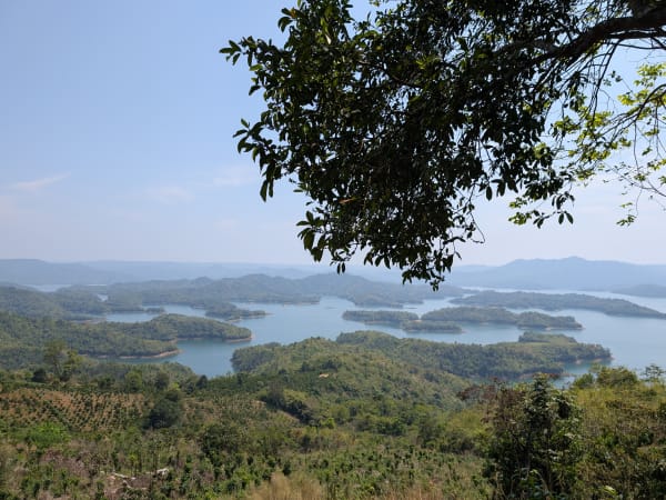
Tà Đùng Lake is a reservoir in Đắk Nông province, formed when the Đồng Nai 3 hydroelectric dam flooded a valley of highland forest. The 47-plus islands visible on the lake surface are not natural formations - they are the hilltops and ridges of terrain that was submerged, with the original forest still standing above the waterline. This origin gives the lake its distinctive character: the islands are covered in dense tropical forest, the water between them is calm, and in the dry season bleached tree trunks emerge from the shallower areas where the submerged forest meets the surface. The lake has earned the informal title of 'Hạ Long Bay of the Central Highlands' for the visual logic of forested islands rising from still water - though the two places share only that basic image. The national park surrounding the lake sits at 700-1,000m elevation with an average temperature of 21-22°C year-round, giving Tà Đùng a genuinely cooler climate than the surrounding lowlands.

🚗 Getting There

Tà Đùng Lake is approximately 250km from Ho Chi Minh City and 60km from Gia Nghĩa (Đắk Nông provincial capital). From Saigon, two route options: (1) via Bình Dương, Bình Phước, QL14 to Gia Nghĩa - about 6 hours; (2) Long Thành - Dầu Giây expressway then QL20 to QL28 via Bảo Lộc - allows an overnight stop in Bảo Lộc en route. Sleeper buses from Saigon to Gia Nghĩa (~7 hours): nhà xe Đại Nghĩa (0978 719 989 / 0973 484 848) or Thùy Linh (1900 888 684). From Gia Nghĩa, rent a motorbike and ride to Đắk Som (about 1.5 hours). From Đà Lạt: 170km via Bảo Lộc, about 3.5-4 hours.

👀 On the Ground

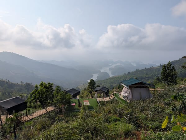
The boat launch area near Đắk Som has boat rentals, food stalls, and the national park office where guides and camping permits are arranged. Boat hire from local fishermen: 500,000-1,000,000 VND per boat. SUP and kayak rentals available. The best photography window is 6-7 AM when morning light hits the water and mist moves between the islands. During the rainy season (Jun-Nov), early mornings occasionally produce a sea of clouds at the lake surface - visible from 5-6 AM. In the dry season the lake level drops, exposing bleached submerged tree trunks for a different kind of visual. Gibbons and hornbills are present in the national park forest - most active in early morning.

🧳 Tips

Book a homestay with a lake view to be in position for the 6-7 AM golden window without travel time. An overnight stay is significantly better than a day trip - the early morning is the defining experience. Tà Đùng fits naturally into a Central Highlands circuit: Đà Lạt - Bảo Lộc - Tà Đùng - Gia Nghĩa coffee country. The Tà Đùng peak trek (1,600m) is worth adding if you have an extra day - contact the national park management in advance. Thác Ông Voi is a good half-day combination.

Based on real traveler experiences and commonly mentioned advice from multiple visitors.

6-7 AM for the best light - book a lake-view homestay to be in position
Jun-Nov: wake up at 5-6 AM for possible sea of clouds on the lake surface
Dry season for blue skies and submerged tree trunks; rainy season for full water level
SUP on the lake + Thác Ông Voi waterfall visit makes a good full day
Boat hire 500,000-1,000,000 VND per boat from local fishermen at the pier
The islands are not natural islands - they are the peaks and ridges of hills and mountains that were submerged when the hydroelectric dam was built. The forest on them is original highland forest that happened to survive above the waterline.
Best time of day: 6-7 AM for soft light and mist on the water. Book a homestay with a lake view so you can get on the water early without a long drive.
Jun-Nov rainy season (5-6 AM): on lucky mornings, a sea of clouds rolls across the lake surface between the islands - one of the more unusual atmospheric effects in the Central Highlands. Not guaranteed but worth waking up for.
Dry season (Nov-Apr): lake level drops, exposing more of the submerged tree trunks above the waterline - eerie and photogenic. Skies are blue and clear. Better for photography.
Rainy season (Jul-Oct): lake at full level, islands appear larger and more dramatic. More misty and atmospheric but weather can interfere with clear views.
SUP and kayaking on the lake between the islands is the main activity - rent at the boat launch near Đắk Som.
Boat hire from local fishermen at the pier: 500,000 - 1,000,000 VND per boat depending on time and group size.
Visit Thác Ông Voi (Elephant Waterfall) nearby - worth combining with the lake visit.
Tà Đùng peak (1,600m) is accessible for trekking - contact the national park management office or forest rangers for guided routes.
From Saigon: ~250km, about 6-7 hours. Two route options: (1) via Bình Dương, Bình Phước, QL14 to Gia Nghĩa; (2) Long Thành - Dầu Giây expressway → QL20 → QL28 via Bảo Lộc (option to overnight in Bảo Lộc en route).
Bus from Saigon: sleeper buses to Gia Nghĩa (~7 hours) - nhà xe Đại Nghĩa (0978 719 989 / 0973 484 848) or Thùy Linh (1900 888 684). Rent a motorbike from Gia Nghĩa to reach the lake.
Average temperature 21-22°C year-round - genuinely cooler than the lowlands.

Common questions from travelers who've visited this place.

Why does Tà Đùng Lake have islands?
The islands are the hilltops and ridges of terrain that was flooded when the Đồng Nai 3 hydroelectric dam was built. The forest on them is original highland forest that survived above the waterline. In the dry season, you can also see bleached tree trunks from the deeper submerged forest emerging above the surface.
When is the best time to visit?
Two distinct windows: November to April (dry season) for blue skies, clear water, and the eerie submerged tree trunks - best for photography. July to October (rainy season) for the lake at full level and the possibility of sea of clouds at 5-6 AM. Year-round temperature is a cool 21-22°C.
How do I get from Saigon to Tà Đùng?
About 250km, 6-7 hours. Two road options: via Bình Dương/Bình Phước/QL14 to Gia Nghĩa, or via Long Thành - Dầu Giây expressway → QL20 → QL28 through Bảo Lộc. Sleeper buses to Gia Nghĩa: Đại Nghĩa (0978 719 989) or Thùy Linh (1900 888 684), ~7 hours. Rent a motorbike from Gia Nghĩa.
What activities are available?
SUP and kayaking between the islands, boat tours, island camping (permit from national park), Tà Đùng peak trek (1,600m - contact national park), and Thác Ông Voi waterfall nearby. Best photography window is 6-7 AM.