Menu
Destinations→Locations→Blog→Map→About→
Forest · ha giang

Yên Minh Pine Forest

The Yên Minh Pine Forest is an unexpected stretch of man-made highland pine on the Ha Giang Loop, spanning Na Khê, Lao Và Chải, and Bạch Đích communes along Highway 4C - dense Pinus kesiya forest at around 1,200 metres, with morning mist threading between the trees and a completely different atmosphere from the surrounding karst landscape. Note: at the Cán Tỷ bridge fork before Yên Minh, only the longer 41km route passes through the forest - the shorter 22.6km route bypasses it entirely.

Highland Pine Forest · Morning Mist · Scenic Road

Yên Minh Pine Forest
Best months
Best time of day
Roughly 5:30-8:00 AM for sunrise mist, or 4:00-5:30 PM for golden late-afternoon light through the pines
Entry fee
Free
Opening hours
Open 24/7
Address
Na Khê - Lao Và Chải - Bạch Đích, Yên Minh, Hà Giang
Crowds
No wait times; very quiet and calm atmosphere
Difficulty
Steep hill requires careful motorbike riding in first gear; walking alternative available
Accessibility
Located right next to highway; easily accessible as roadside stop - but confirm you're on the 41km route at the Cán Tỷ fork, since the shorter 22.6km alternative bypasses the forest
Seasonal
Best in autumn (September-November) and spring (March-April)

What Makes Yên Minh Pine Forest Special

The Yên Minh Pine Forest is a man-made stand of highland Pinus kesiya, spanning Na Khê, Lao Và Chải, and Bạch Đích communes along Highway 4C at around 1,200 metres elevation - a band of forest that interrupts the karst limestone landscape of the Ha Giang plateau. Accounts describe the pine belt running for as much as 50km along QL4C in the wider area, with some sources citing a core area of around 98 hectares.

The forest is unusual for the region: most of the Đồng Văn Karst Plateau is bare limestone, grass, and scrub, with occasional patches of secondary growth. This planted pine forest, sometimes nicknamed a 'mini Đà Lạt' for its cool climate and tall, straight trunks, stands in deliberate contrast.

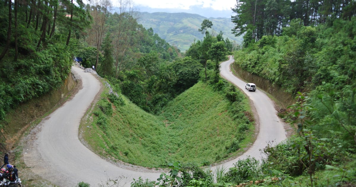
The road through the forest runs on an elevated ridgeline, with the pine canopy above and valley views through the trees on both sides. In the mornings, especially from October through February, mist collects in the forest and drifts between the trunks, creating an atmosphere that feels more like the Scottish Highlands than Vietnam.

How to Get to Yên Minh Pine Forest

The Yên Minh Pine Forest is on Highway 4C in Yên Minh district, roughly 100km northeast of Hà Giang city. All riders on the standard Ha Giang Loop pass through the area, but there's an important routing detail: after Quản Bạ, at the Cán Tỷ bridge, the road forks into a shorter 22.6km route and a longer 41km route toward Yên Minh - only the 41km route actually passes through the pine forest, so it's worth confirming you're on the right road if the forest is a priority for you.

From Quản Bạ Heaven Gate, continue along Highway 4C for roughly 30km to reach the Cán Tỷ fork, then take the 41km route - the pine forest begins along this stretch.

Motorbike rental in Hà Giang typically runs 150,000-200,000 VND/day. Yên Minh town at the eastern end of the forest is the standard overnight stop for the first night of the loop.

What to Expect at Yên Minh Pine Forest

The road through the forest is straight by Ha Giang standards - long enough sections to ride at a comfortable pace before the next bend. The pine canopy provides shade and the temperature drops noticeably in the forest compared to exposed karst sections. Pullouts and clearings offer stopping points with views through the trees or out over the valleys.

In mist conditions, the visibility reduces to 50-100 metres between the trunks and the road ahead disappears into white - disorienting and atmospheric simultaneously. Yên Minh town at the forest's eastern end has guesthouses, restaurants, and petrol - standard loop overnight stop facilities.

Travel Tips for Yên Minh Pine Forest

The pine forest is a mood shift on the loop - a respite from the dramatic exposure of the karst passes, quieter and more enclosed. Riders who rush through, or who accidentally take the shorter 22.6km route around it, miss the particular quality of the forest morning light and mist entirely.

The 30-minute walk from any pullout into the forest interior, where the trees are denser and the road inaudible, is one of the more meditative experiences available on a loop that is otherwise about movement and views. Yên Minh town, at the forest exit, is a better overnight stop than its facilities suggest - the guesthouses are basic but the town is quiet and the morning ride from Yên Minh toward Đồng Văn the next day is the best single day of riding on the loop.

Based on real traveler experiences and commonly mentioned advice from multiple visitors.

  • Use first gear when riding motorbike up the steep pathway to avoid difficulties
  • Be cautious of wasps near the WC facilities; toilet conditions are very poor
  • Avoid littering; significant trash pollution exists despite bins being available
  • Time needed: 1-2 hours for photos and a short walk, or half a day to overnight if camping
  • ⚠️ Important routing note: at the Cán Tỷ bridge (after Quản Bạ), a fork offers two routes to Yên Minh - a shorter 22.6km option and a longer 41km option. Only the 41km route passes through the pine forest, so double-check you're on the right road if seeing the forest matters to you
  • Ride through in the early morning (roughly 5:30-8:00 AM) for the mist effect - by 9-10 AM the sun burns the mist off and the forest is pleasant but less atmospheric
  • Late afternoon (around 4:00-5:30 PM) is the other strong window - the low sun creates long golden shafts through the pine canopy
  • The forest road has several pullouts where you can stop and walk into the trees - 5 minutes off the road and the traffic disappears completely
  • Night camping in the forest is technically possible but check with local authorities - the area is sometimes used by rangers and overnight camping rules vary. If you're doing a campfire or BBQ, be careful with fire safety given the surrounding pine forest
  • Wear sturdy, low-soled shoes if you plan to walk into the forest interior
  • The transition from karst limestone landscape to pine forest and back is one of the most striking geographical changes on the loop - pay attention to where it begins and ends

Common questions from travelers who've visited this place.

How difficult is it to ride a motorbike up the hill?
The hill is steep; use first gear. If uncomfortable, park at the bottom and walk up instead.
What facilities are available at the pine forest?
Local cafe sells drinks, tea, snacks, and beer at reasonable prices. Benches and plastic chairs available for rest.
Is it worth stopping here during the Ha Giang Loop?
Yes, recommended as a break from driving with cool atmosphere and photo opportunities, though not essential. Just make sure you're on the 41km route at the Cán Tỷ fork - the shorter 22.6km option bypasses the forest entirely.

Explore more things to do like this around Vietnam

Explore more

ha giang - Full Guide

View destination guide →